username
X
password
register
for free!
help
  🔥

Juniper Flat - Sierra Ancha, AZ

Guide 2 Triplogs  0 Topics
  3.5 of 5  
Fav
Wish
0
details
drive
no permit
forecast
🔥
route  
stats
photos
triplogs
topics
location
15 2 0
Statistics
tap row or icons for details
Distance One Way 6 miles
Trailhead Elevation 6,349 feet
Elevation Gain -360 feet
Accumulated Gain 550 feet
Kokopelli Seeds 7.83
 Interest Off-Trail Hiking & Seasonal Waterfall
feature photo
Photos Viewed All MineFollowing
Inaugural Calculation on Button Tap!
15  2020-05-21 kingsnake
42  2014-02-18
Elephant Rock Arch - Sierra Ancha
Grasshopper
Author
author avatar Guides 595
Routes 0
Photos 0
Trips 247 map ( 429 miles )
Age ?
Location
Associated Areas
list map done
Globe Region
Historical Weather
Trailhead Forecast
Radar Map
Expand Map
Preferred Apr, Mar, Nov, Oct
Sun  6:00am - 6:44pm
Official Route & 1 Rt
 
1 Alternative
 
Historic Fire Perimetersacres
🔥 Turkey 20108.4 mi*
🔥 2016 Juniper Fire30.6k
🔥 View (All) - over Official Route 🔥
*perimeter length in miles


remove free decal offer

Guide Needed
Publish Full Detail Guide


Use +Add above to share photos and triplogs
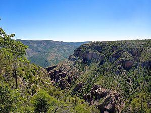
Juniper Flat is roughly bounded by the Young Highway / AZ-288 on the west, Elephant Rock to the south, the Cherry Creek rim to the east and the pass at Turkey Spring to the north. There is an unnumbered dirt road outside the Wilderness, but otherwise it is all off trail, the main objective being to enjoy the vistas overlooking Cherry Creek. There is a dryfall -- which would be spectacular if water is running -- just off the dirt road.


    Check out the Official Route and Triplogs.
    Leave No Trace and +Add a Triplog after your hike to support this local community.

    One-Way Notice
    This hike is listed as One-Way.

    When hiking several trails on a single "hike", log it with a generic name that describes the hike. Then link the trails traveled, check out the example.
    WARNING! Hiking and outdoor related sports can be dangerous. Be responsible and prepare for the trip. Study the area you are entering and plan accordingly. Dress for the current and unexpected weather changes. Take plenty of water. Never go alone. Make an itinerary with your plan(s), route(s), destination(s) and expected return time. Give your itinerary to trusted family and/or friends.

     Permit $$
    None


     Directions
    or
     Road
    FR / Dirt Road / Gravel - Car Okay

    To hike
    Depending on where you live in the Valley, there are two general ways to get to the Sierra Ancha: From the south & east Valley, take US-60 to Globe, then AZ-188 north towards Roosevelt Lake. From other parts of the Valley, exit the Loop 101 at Shea. Go east on Shea to the Beeline Highway (AZ-87). Go north on the Beeline Highway for 46 miles to AZ-188. Go east on AZ-188 for 46 miles, passing through the small communities of Jake’s Corner, Punkin Center, Tonto Basin and Roosevelt. Turn north onto the Young Highway (AZ-288). The road is narrow & twisty as it climbs into the Sierra Ancha, so mind your speed. In ~22 miles, as AZ-288 crests the climb, it turns to car drivable dirt. In ~9 more miles, just past FR 561 to the McFadden Lookout, on the right will be a pullout. Park there. You’ll need an SUV to cross the shallow ditch at the edge of the road.
    page created by kingsnake on May 23 2020 3:12 pm
     90+° 8am - 6pm kills
    helpcorrectionissue

    end of page marker