 Route Editor

| Guide | ♦ | 3 Triplogs | 1 Topic |
details | drive | permit | forecast | 🔥 route |
stats |
photos | triplogs | topic | location |
| 38 | 3 | 1 |
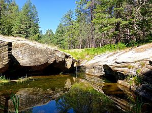
A Fist Full of Kehls by kingsnake   Prologue PrologueThe various Kehl Canyons are located between Kehl Ridge and Blazed Ridge, just west of FR 141: Kehl Canyon Runs 5.0 miles from the edge of the Mogollon Rim, through Kehl Springs, to East Clear Creek. (The first mile is basically Rim Rd. / FR 300.)
Stretches 2.2 miles from FR 308, past Mud Spring, to Kehl Canyon. Middle Kehl Canyon Splits the two, 1.5 miles from FR 308 to Kehl Canyon. Hike Kehl Springs Campground serves as the trailhead, but you could also park off FR 308 at either FR 308E, near West Kehl Canyon, or off FR 308 at FR 308A, near Middle Kehl Canyon. Regardless of where you park, if you do the loop in the attached GPS route, the mileage and accumulated elevation gain (AEG) is about the same: 8.6 miles, 750 ft. AEG. There are options for shorter loops: North Loop Starting from FR 308E, heading clockwise, hike the bottom 0.3 miles of Middle Kehl Canyon, north in Kehl Canyon for 2.2 miles, then 2.5 miles south in West Kehl Canyon back to where you started. The north loop is 5.5 miles and 400 ft. AEG. South Loop Starting from Kehl Springs Campground, hike north in Kehl Canyon for 1.6 miles, then south in Middle Kehl Canyon for 2.4 miles back to where you started. The south loop is 4.0 miles and 400 ft. AEG. If at any point you get tired of canyon crawling, there are forest roads that parallel the canyon bottoms, anywhere from 20-200 ft. upslope: FR 308E for Kehl Canyon, FR 308B for Middle Kehl Canyon, and FR 6110 for West Kehl Canyon. Check out the Official Route and Triplogs. Leave No Trace and +Add a Triplog after your hike to support this local community. One-Way Notice This hike is listed as One-Way. When hiking several trails on a single "hike", log it with a generic name that describes the hike. Then link the trails traveled, check out the example. | |||||||||||||||||||||||||||||||||||||||||||||||||||||||||||||||||||||||||||||||||||||||||||||||||||


