Route Editor

| Guide | ♦ | 4 Triplogs | 1 Topic |
details | drive | no permit | forecast | 🔥 route |
stats |
photos | triplogs | topic | location |
| 23 | 4 | 1 |
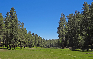
  Overview OverviewIf already in the area, this is a very enjoyable, relaxing, scenic, easy to off-trail navigate, short loop hike (2 to 2.5hrs to complete). It includes hiking on some lesser-used open and closed to vehicle traffic Forest Roads. On this loop, hiking within the green, lush Middle Merritt Draw to view two of the three fenced-in Historic Merritt Draw Riparian Areas. This hike goes by Historic, Perennial Merritt Spring Box Source, and also hikes by at least three other Middle Merritt Draw perennial, unnamed Spring sources. All Spring locations are waypoint detailed on this Hike Guide, "Official" posted Gps Route.
Oh yea! Check out the Official Route and Triplogs. Leave No Trace and +Add a Triplog after your hike to support this local community. | ||||||||||||||||||||||||||||||||||||||||||||||||||||||||||||||||||||||||||||||||||||||||