Route Editor

| Guide | ♦ | 10 Triplogs | 0 Topics |
details | drive | no permit | forecast | route |
stats |
photos | triplogs | topics | location |
| 101 | 10 | 0 |
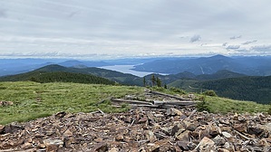
spectacular summit views by LindaAnn Hike: Starting at the junction of FS-332 (Bunco Rd) & FS-385, there is a fiberglass marker at the southwest corner. The trail heads uphill towards the southwest, heading up a ridge between the two roads. The elevation gain is steady, and you will be surrounded by trees. The first quarter mile or so of the trail follows an old roadbed, before turning to a single track and switchbacking uphill.
After taking the left fork, the trail heads south and up into the talus. The trees disappear, and the trail becomes rocky as it winds through the talus field. At the summit, there are the remains of what appears to have been a tower and possibly a small building. Views in all directions are spectacular. Once you've soaked in the views, retrace your steps back downhill to the north, or continue to head south off the summit and make your way over to South Chilco. The hike back to the trailhead is a steady downhill and goes by quickly. Check out the Official Route and Triplogs. Leave No Trace and +Add a Triplog after your hike to support this local community. | |||||||||||||||||||||||||||||||||||||||||||||||||||||||||||||||||||||||||||||||||||||||||