Route Editor

| Guide | ♦ | 6 Triplogs | 0 Topics |
details | drive | permit | forecast | route |
stats |
photos | triplogs | topics | location |
| 63 | 6 | 0 |
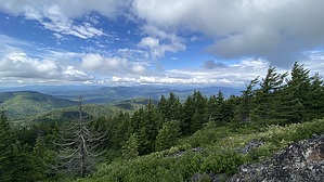
The first mile is mostly switchbacks in the trees, although views start to open up after about three-quarters of a mile. You will notice that the newly rerouted trail intersects with the old trail in several places. The correct trail is not always obvious, but choosing the less steep option keeps you on the newer trail.
After taking the fork, you'll climb another thirty feet or so before mostly leveling off as you head south. Just before reaching the summit, you'll climb another twenty feet or so up some talus steps. Atop Blacktail, there are views in all directions due to no trees on the summit. Lake Pend Oreille is just below you to the east. There are plenty of rocks to sit on at the summit and soak in the scenery. Retrace your steps back down, with the option at the saddle to take the left fork over to Butler Mountain for an additional 1.50 miles on your hike. The hike back down goes quickly, although there is some loose rock on the trail in a few places. Check out the Official Route and Triplogs. Leave No Trace and +Add a Triplog after your hike to support this local community. | |||||||||||||||||||||||||||||||||||||||||||||||||||||||||||||||||||||||||||||||||||||||||