 Route Editor

| Guide | ♦ | 19 Triplogs | 3 Topics |
details | drive | no permit | forecast | 🔥 route |
stats |
photos | triplogs | topics | location |
| 281 | 19 | 3 |
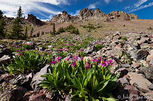
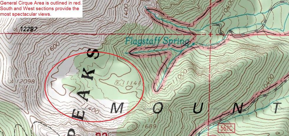
A Path Less Taken by hippiepunkpirate  Cirque CirqueFirst of all, you are most likely thinking to yourself, "What the heck is a cirque?" A cirque is a geologic term for a depression formed during the process of alpine glaciation. A glacier begins to form when heavy snow builds up enough to compact into dense ice sheets. The top of the glacier attaches itself to the mountain, on what is called the headwall. Near the headwall, the ice is the densest, which causes the ground below it to depress, forming a cirque. From approximately 100,000 years to about 10,000 years, the San Francisco Peaks went through four periods of glaciation, leaving behind glacial landforms such as cirques, moraines, and aretes. The top of the Inner Basin Trail approaching the Weatherford is actually in a cirque. However, the goal of this hike is to reach the top of the mountain's largest cirque, located just above Flagstaff Spring. In my opinion, it is one of the most spectacular areas on the mountain, with the offering of solitude.
This hike is described as being hiked from the Inner Basin Trailhead at Lockett Meadow, completed by my father and me on July 16, 2009. To reach the cirque, you must first reach Flagstaff Spring, which requires hiking roads built by the City of Flagstaff to maintain their water supply. Upon reaching Flagstaff Spring, off-trail route-finding through dense forest and steep terrain is required to reach the cirque. A Humphrey's Peak topographic map from USGS is helpful and recommended for navigating the roads and off-trail hiking. The TrailDex Map using one of the topo overlays may suffice. Warning This hike is off the beaten path, so always be aware of your surroundings, especially the weather. The top of the cirque is at treeline, so exposure to lighting is a definite factor. If you get into trouble, it is unlikely another hiker will stumble upon you, and help may not be able to reach you quickly. Also, I recommend bringing some sort of walking stick to aid in descending from the cirque back down to Flagstaff Spring. Note It looks as if the cirque may be accessible from Humphrey's Summit Trail. Getting down into the cirque from the saddle would require descending the headwall, which is extremely steep. I'm guessing it's class 4+ and with all that loose scree, extremely dangerous. Hike From the trailhead, head up the Inner Basin Trail. At 1.5 miles, you will reach the intersection with the Waterline Road (FR 146), the "cabin", and the trail register. It would be a good idea to sign it and list your desired destination. Continue up the Inner Basin Trail a short distance (100 yards?) and you will come to a junction. This is where the topo starts to come in handy. A sign will indicate that the official Inner Basin Trail is left; you will want to veer to the right. At this point, you are leaving the crowds behind and starting an adventure in solitude (unless you meet a City of Flagstaff Water truck). As you continue through the dense forest, an opening here and there allows for quick glimpses of Doyle Peak. You soon reach another junction. Keep going straight (turning left takes you to the meadow). The map shows a couple more junctions before Flagstaff Spring, but those roads are no longer maintained, so you won't need to worry about them. Before Flagstaff Spring, you will come across Bear Paw Spring, which has a wooden sign indicating its location just to the left of the road. It isn't too exciting, and it tends to be a seep. There's a lovely meadow that opens up here, and you can see Fremont Peak looming over the Core Ridge. When you reach Flagstaff Spring, a lush alpine riparian zone awaits. A rusted metal pipe sticks out of the ground, and the maintenance road disappears suddenly. This is where the off-trail fun starts. The metal pipe is what the map indicates as the spring. Water actually comes out from above. On the map, you will notice that the canyon forks above. It seems easiest to climb the slope between these two forks. When I came through in July 2009, Flagstaff Spring was not really flowing, although the damp ground indicated that the water level was very close to the surface. My dad reports that in June 2009, Flagstaff Spring was flowing nicely. Make sure to keep left when you ascend the riparian zone. There is avalanche damage to the right, and it isn't enjoyable to navigate. After a few hundred feet, the canyon begins to fork, and you will need to look for a faint path heading up into the trees. If you miss it, get out of the riparian area and head up the slope. In June 2009, my dad had to turn back at this point due to snow (lacking proper gear). In July 2009, we followed the faint trail from the riparian zone (it disappeared within a few hundred feet) and soon began finding our own way amongst the trees. Maybe two-thirds of the way to the lip of the cirque, as the hill continued to steepen, we caught a game trail in a south-westerly direction until we reached the lip. As before, if you miss the game trail, keep heading up. Once on the cirque, it's more of an area to explore than a specific destination. I found that the coolest areas were in the south and west areas of the cirque, which are more open and provide breathtaking views of the Core Ridge and the Humphrey's Ridgeline. The Core Ridge is likely the main volcanic vent that provided lava and whatnot to this beastly mountain back in its heyday. The Core Ridge is also a glacier-carved feature called an arete, which is a ridgeline steepened by cirques carved into it on two sides. During our July 2009 trip, a couple of patches of snow remained, with great-tasting water flowing down into the cirque and the bitter-sweet smell of alpine wildflowers lofting into the air. Make sure to spend some time up here and experience all the magic of this sweet, sweet area! A map showing the cirque is provided here.
Check out the Official Route and Triplogs. Note This is a moderately difficult hike. Leave No Trace and +Add a Triplog after your hike to support this local community. | ||||||||||||||||||||||||||||||||||||||||||||||||||||||||||||||||||||||||||||||||||||||||||||||||||||||||||||


