From the Talache-Blacktail Trailhead, take the trail northeast out of the parking area. The trail immediately starts gaining elevation and it steep and rocky in places. The first mile is mostly switchbacks while you are shrouded in trees. Views start to open up after about three-quarters of a mile. The trail has recently been rerouted and intersects the old trail in several places. If the correct trail is not obvious, always choose the less steep option and that will keep you on the newer reroute.
After a mile, the switchbacks lessen, but the trail gets steeper for the next mile. At two miles, you will reach a saddle where the trail splits. It's highly recommended to make the short side detour on the right fork for a quick visit to Blacktail Mountain. The left fork at the saddle continues north to Butler Mountain.
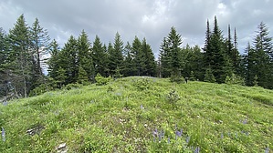
The next three-quarters of a mile is relatively flat as the trail heads north up to Butler. The summit isn't obvious, but you can tell when you seem to reach the highest point of the ridge. The summit is in a meadow, and heading left (west) off the trail for about thirty feet to the highest spot is basically the summit. There were several rocks painted yellow that seemed to be marking the summit--my guess is that it was an old cairn that has been knocked over. There are not many places to sit, and views are limited due to being surrounded by trees ringing the meadow.
Once done, retrace your steps back down to the trailhead. The hike back down goes by quickly but is steep, and rocky in several places.
WARNING! Hiking and outdoor related sports can be dangerous. Be responsible and prepare for the trip. Study the area you are entering and plan accordingly. Dress for the current and unexpected weather changes. Take plenty of water. Never go alone. Make an itinerary with your plan(s), route(s), destination(s) and expected return time. Give your itinerary to trusted family and/or friends.
Permit $$
FS
Directions
Road
Paved - Car Okay
To Talache-Blacktail Trailhead From Coeur d'Alene, take Hwy 95 north to Blacktail Rd, north of mile marker 462. There are several Blacktail Roads in the area, so make sure you take the correct Blacktail. This road is in the small "town" of Cocolalla. Turn right (east) onto Blacktail Rd and follow it east to Butler Creek Rd. Turn left onto Butler Creek Rd and follow it east as it turns into FS-230. Take FS-230 east to the signed Talache-Blacktail Trailhead on the left side of the road.
Searching for "Maiden Rock Trailhead" in Google Maps also provides good directions.
From Boise - 7 h 43 min (414 miles) From Spokane - 1 h 18 min (64.2 miles) From Idaho Falls - 8 h 8 min (514 miles)
 Route Editor