 Route Editor

| Guide | ♦ | 1 Triplog | 0 Topics |
details | drive | permit | forecast | route |
stats |
photos | triplog | topics | location |
| 9 | 1 | 0 |
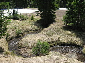
Fire and Ice by AZLOT69 Hike: From the road the trail takes off across an open meadow and meanders towards a natural drainage on the horizon. Snows normally last well into July here making the trail difficult if not impossible to follow. Bearing towards the right side of the apparent drainage ahead will get you on course. Topo maps and GPS were a great asset as I located no other human footprints in the snow. The drainage is thick with trees and much downfall from winter adding to the challenge. The trail follows this same pattern of meadow-drainage down three seemingly terraced levels. If in doubt stay to the drainage on the right. At 1.5 miles you arrive at a signed, designated Pacific Crest Trail Campground. It is in a nice tree covered hollow with Lightning Spring, a reliable source of water only a quarter mile away. If there is still snowfall on the ground the trail gets faint again in this area. After retracing steps a few times, I figured out that there are markings thirty feet high in the trees for cross country skiers use. The blue reflector diamond shaped emblems can be seen for quite a long distance ahead and give you a general direction of the trail. The trail passes directly by Lightning Springs at this point which has a healthy flow. This flow quickly joins other spring runoff into larger and larger creeks. The trail goes thru several interesting sections of forest and rock outcroppings. A couple of surprise switchbacks are navigated easy by the now obvious blue reflectors. After going thru a burned out section of the forest the sound of moving water gets louder and louder as the trail finally parallels Bybee Creek. Bybee Creek will be on your left for the final mile of this trails end at the Pacific Crest Trail. You can continue on North or South on the Pacific Crest Trail or return the way you came. Check out the Official Route and Triplog. Leave No Trace and +Add a Triplog after your hike to support this local community. One-Way Notice This hike is listed as One-Way. When hiking several trails on a single "hike", log it with a generic name that describes the hike. Then link the trails traveled, check out the example. | ||||||||||||||||||||||||||||||||||||||||||||||||||||||||||||||||||||||||||||||||||||||


