 Route Editor

| Guide | ♦ | 7 Triplogs | 0 Topics |
details | drive | permit | forecast | route |
stats |
photos | triplogs | topics | location |
| 105 | 7 | 0 |
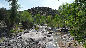
Come wander on the BCT by topohiker   Overview OverviewThe Black Canyon Trail (BCT) is recognized as a National Recreational Trail and when complete, will meander from Carefree Highway (AZ74) north to the city of Williams (about 130 miles). There are a number of guides on this HAZ covering various segments of the BCT. This guide covers the trail that starts at the intersection of Orme road (county road 169) and county road 68B. This section ends at the intersection of the General Crook trail and SR169. From my experience, there are two versions of the BCT. The initial design of the trail follows existing forest or farming roads. The trail was marked by a brown triangle sign with the words “Black Canyon Trail” and a picture of a person riding a horse & a hiker. The newer BCT is a single track that avoids roads whenever possible and the trail marker is a brown carbonite post.
Hike The trail starts near the intersection of Orme Road and county road 68B on FR9602W. The trail climbs to a gate and then drops to Osborne Well. The well area has some water that has been trampled by cattle. There is a hidden gate to a well. Keep on following FR9602W to FR9650T and turn right. The trail crosses the Ash creek. Around the Cienega Tank area, there is a short wooden bridge that has the last triangle BCT signpost. I didn’t see any other signs past that point. I did run into a rancher who told me to just keep on following the roads to SR169. After this point, I keep on following roads that took me north to SR169. These roads see very little use. About a half before FR9650T runs into I-17 there is an unnumbered road that leads to Sheep spring / FR9650X. Turn to the left on FR9650X (away from I-17). Soon you’ll come across the Cienega Creek & Racetrack wash confluence. The road runs into FR960F which runs into the General Crook Trail. At this point, I was done guessing where to go next. I really don’t have any logical guess where the BCT goes from here (assuming this is where the BCT leads to). It would be a simple shuttle hike to place a vehicle at SR169/SR9604F (General Crook) and FR9602W roads. Update 3/27/2022 The BCT association has officially rerouted the Orme Road to General Crook trail near the South Old Cherry RD. This is total reroute none of the original trail is used. Plus, this all-new constructed trail. There is no road walking. From the TH, cross the road and look for the Trail 64 sign. The General Crook trail can get sketchy at times. Look for the cairns. About 1.2 miles, you’ll run into the General Crook / BCT intersection. Turn right (south). Immediately you’ll see the difference in trail quality. The BCT is about two feet wide with soft trail. About 1.4 miles in you’ll cross a fence line with a new bike ramp. About 2.8 miles in your cross S Old Cherry rd, and another bike friendly gate. You’ll cross the Ash creek and climb up to a cool rock field with awesome views of the Ash Creek. There are numinous break/lunch spots with great views. You’ll cross numerous washes. There are Juniper trees here and there. There’s one last bike friendly gate as you start your last descend to the Orme Road TH. One the way back I noticed there was a sign showing the BCT following the General Crook trail to east. I believe the BCT will follow the GC to the to about SR260. But as of this writing I have no definite details. Gate Policy: If a gate is closed upon arrival, leave it closed after you go through. If it is open, leave it open. Leaving a closed gate open may put cattle in danger. Closing an open gate may cut them off from water. Please be respectful, leave gates as found. The exception is signage on the gate directing you otherwise. Check out the Official Route and Triplogs. Leave No Trace and +Add a Triplog after your hike to support this local community. One-Way Notice This hike is listed as One-Way. When hiking several trails on a single "hike", log it with a generic name that describes the hike. Then link the trails traveled, check out the example. | ||||||||||||||||||||||||||||||||||||||||||||||||||||||||||||||||||||||||||||||||||||||||||||||||||||||||||||||||||||||||||||||||||||||||||||||||||||||||||||||||||||||||||||


