Route Editor

| Guide | ♦ | 4 Triplogs | 1 Topic |
details | drive | permit | forecast | 🔥 route |
stats |
photos | triplogs | topic | location |
| 58 | 4 | 1 |
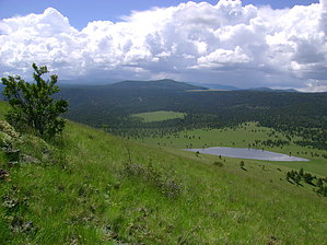
Short Workout with a 360 Degree View by azbackpackr  If you're visiting Greer, Eagar, or Springerville, and you've been looking for a short "workout" hike a bit off the beaten track, climbing Antelope Mountain fits the ticket very well. A big grass-covered volcanic cinder cone is just north of State Highway 260, not far from the Greer turnoff. Featuring superb views in all directions, the 4-to-5 mile roundtrip hike is on both National Forest and State Trust Land, so technically, you'd need the State permit. (Do I have one? I'll take the Fifth...) If you're visiting Greer, Eagar, or Springerville, and you've been looking for a short "workout" hike a bit off the beaten track, climbing Antelope Mountain fits the ticket very well. A big grass-covered volcanic cinder cone is just north of State Highway 260, not far from the Greer turnoff. Featuring superb views in all directions, the 4-to-5 mile roundtrip hike is on both National Forest and State Trust Land, so technically, you'd need the State permit. (Do I have one? I'll take the Fifth...)For a genuinely aerobic workout, you can hike straight up the side of the mountain... and trust me, it's steep! You can follow an old dirt road that goes to an abandoned radio tower on the 9003-foot summit for a somewhat easier route. This road is easily visible from Highway 260.
Forested only on its north-facing slope, Antelope Mountain's west, south, and east slopes are covered in grasses. Since these latter three sides receive a lot of hot sun and dry harsh winds, they have adapted to grasslands, whereas the steep northern slope is shadier and, therefore, somewhat damper and can support trees. Surprisingly, many trees live in the little patch of forest on the north slope, including aspen, fir, and Ponderosa pine. Those trees which have survived close to the summit are bent, bonsai-like, by the constant wind. Named for an early pioneer, nearby Ellis Wiltbank Reservoir serves as a holding tank for water to irrigate some of the ranchlands and hay fields at lower elevations and provide water for cattle grazing. But for wildlife, it is also essential. Migratory birds such as ducks and geese find it a convenient stopover. Deer, elk, antelope, and smaller animals and birds drink from it as well. I spotted several hawks and kestrels, along with the ubiquitous noisy black ravens. And as I hiked, my ears were treated to the melodious but repetitive warble of the meadowlark. The 360-degree view from the summit is well worth the effort of making the climb. Ten miles to the east, the little towns of Springerville and Eagar nestle next to Round Valley. That giant pink mushroom in the center of the two towns is the Round Valley High School Dome, where the students play basketball, volleyball, and football during the cold winters. Further to the east, the isolated peaks of western New Mexico are visible... I believe you could see Mt. Taylor if it's clear enough. Panning your vision in a broad arc, from west to south, you'll see the dark forests of the main spine of the White Mountains--its hills, peaks, and basalt lava rimrock. Mt. Baldy can be seen to the south-southwest, about 14 miles away, if not covered in clouds. About 7 miles due west is 10,133 foot Green's Peak, crowned with a "microwave forest" of cell phone and radio towers, plus a forest fire lookout tower. Pole Knoll is the forested hill in the southwest foreground of the view. Since this area is mostly part of a cattle grazing lease belonging to Sug Peters of South Fork, PLEASE kindly leave any gates as you find them. A little respect goes a long way in engendering goodwill amongst various groups of people who visit and use the backcountry. Gate Policy: If a gate is closed upon arrival, leave it closed after you go through. If it is open, leave it open. Leaving a closed gate open may put cattle in danger. Closing an open gate may cut them off from water. Please be respectful, leave gates as found. The exception is signage on the gate directing you otherwise. Check out the Official Route and Triplogs. Leave No Trace and +Add a Triplog after your hike to support this local community. | ||||||||||||||||||||||||||||||||||||||||||||||||||||||||||||||||||||||||||||||||||||||||