 Route Editor

| Guide | ♦ | 8 Triplogs | 0 Topics |
details | drive | no permit | forecast | 🔥 route |
stats |
photos | triplogs | topics | location |
| 11 | 8 | 0 |
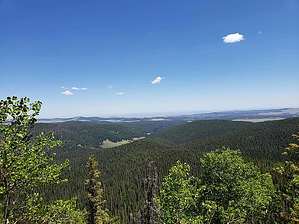
 Overview OverviewThis perch is a 1-minute detour off the official trail on a well-worn spur with views of West Baldy Trail #94 & meadows from above. Keep in mind, that the East & West Baldy trail junction offers zero views. This is the only high perch viewpoint on Mt Baldy near an official trail. Warning This trail is part of the Mount Baldy Wilderness area. The US Forest Service has a group size maximum of 12 hikers & a maximum of 6 for overnight backpacking.
This hike initially follows the East Fork of the Little Colorado River as well as some often lush meadows for about 1.5 miles before a 900-foot climb to some beautiful hoodoos and incredible views of the Mt Baldy Wilderness as well as the surrounding area from the nearly 10,200-foot overlook at mile 2.5 ( nearly halfway and only 600ft AEG to the perch at mile 5.4 ) Deadfall Trail deadfall is usually cleared by July 4th. Check with the Springerville USFS office for current trail conditions or recent trip reports here on HAZ. Snow & Trailhead Access Snow can be problematic sometimes as early as mid-October and present on the upper portions of the trail as late as June. Highway 273 to trailhead closes each winter but is often open into Dec and usually re-opens by mid-April. Check the AZ511 website for current highway info. Check out the Official Route and Triplogs. Leave No Trace and +Add a Triplog after your hike to support this local community. One-Way Notice This hike is listed as One-Way. When hiking several trails on a single "hike", log it with a generic name that describes the hike. Then link the trails traveled, check out the example. | |||||||||||||||||||||||||||||||||||||||||||||||||||||||||||||||||||||||||||||||||||||||||||||||||||


