Route Editor

| Guide | ♦ | 1 Triplog | 0 Topics |
details | drive | permit | forecast | route |
stats |
photos | triplog | topics | location |
| 13 | 1 | 0 |
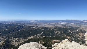
Powell was never here? by LindaAnn Hike: Depending on your vehicle, the hike to Powell Point can be as short as 1.60 miles round trip, or as long as 9.10 miles round trip.
4WD parking/Official trailhead: From the official trailhead, head south on the trail past the sign. The trail heads west, then east on a large switchback as it heads downhill. The trail turns south across a spine, then regains elevation. Views to the west are best at this point, but as you near the end of the plateau, you can see in all directions across southern Utah. Vegetation shifts to bristlecone and limber pines as you approach Powell Point. There is an interpretive sign at the end of the trail. Plenty of room to walk around and take pictures. When done, retrace your steps back to the trailhead. Warning: The limestone slopes at the edge of the plateau are steep and slippery, use caution near the cliff edges, sometimes the traction is as exciting as walking on marbles if you venture off-trail. Summer thunderstorms also gather above the plateau, do not stand near the cliff edges if lightning is nearby. Check out the Official Route and Triplog. Leave No Trace and +Add a Triplog after your hike to support this local community. | |||||||||||||||||||||||||||||||||||||||||||||||||||||||||||||||||||||||||||||||||||||||||