Route Editor

| Guide | ♦ | 3 Triplogs | 0 Topics |
details | drive | no permit | forecast | 🔥 route |
stats |
photos | triplogs | topics | location |
| 38 | 3 | 0 |
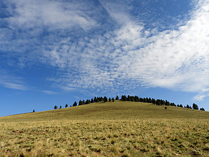
Greens Peak's little sister by outdoor_lover  Warning This Hike falls within a designated Wildlife Habitat Area. No Motorized Vehicles within this area. With that said, there are scars on this hill from people using motorized vehicles to get to the top. Do not use these scars as your route as steps are being taken to prevent erosion and allow the vegetation to heal. Please tread lightly and be conscious of your footprint, as this is an Off-Trail Hike. Also, realize that you are hiking in a Habitat Area, and you may be treading on homes. I came up upon a Badger's front porch doing this hike. Luckily he was not home, but I made a point to try not to crush anyone's home, including his. It is my understanding that there may be Long-tailed Weasels living in burrows up there as well. Warning This Hike falls within a designated Wildlife Habitat Area. No Motorized Vehicles within this area. With that said, there are scars on this hill from people using motorized vehicles to get to the top. Do not use these scars as your route as steps are being taken to prevent erosion and allow the vegetation to heal. Please tread lightly and be conscious of your footprint, as this is an Off-Trail Hike. Also, realize that you are hiking in a Habitat Area, and you may be treading on homes. I came up upon a Badger's front porch doing this hike. Luckily he was not home, but I made a point to try not to crush anyone's home, including his. It is my understanding that there may be Long-tailed Weasels living in burrows up there as well.Overview If you're looking for a quick hike with some great views, but don't feel like doing more elevation on Greens Peak, this is your ticket. While there are no views at the high point itself due to trees, the ascent, ridgeline, and descent-ridges all give you some wonderful views. As far as an off-trail ascent and descent go, it doesn't get much easier than this, for the amount of elevation you gain in such a short time. But it's a great little warm-up for other hikes in the area, or if you're just short on time.
A nice option in the Greens Peak area for those looking for a short, sweet little hike. Enjoy and watch out for resident badger. Check out the Official Route and Triplogs. Leave No Trace and +Add a Triplog after your hike to support this local community. | ||||||||||||||||||||||||||||||||||||||||||||||||||||||||||||||||||||||||||||||||||||||||||||||