Route Editor

| Guide | ♦ | 3 Triplogs | 0 Topics |
details | drive | no permit | forecast | route |
stats |
photos | triplogs | topics | location |
| 58 | 3 | 0 |
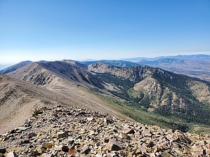
views in every direction by ShatteredArm North Schell Peak (elevation 11,883) is a largely overlooked peak that has the distinction of being on the list of 57 "ultraprominent" (topographic prominence of 5k feet - or 1500 meters by some definitions - or more) peaks in the lower 48. Being only 23.5 miles as the crow flies from Wheeler Peak, it has relatively low isolation, but it's also a convenient peak to bag if you're in the Ely area, and it's a worthwhile side trip if you'd like a different sort of challenge to go with Wheeler. It also offers quite a bit more solitude than the National Park. A Note On Mileage This guide assumes you are starting at the actual trailhead. Any stock truck or SUV can easily reach the trailhead, but if you have low clearance, you will have to park in the campground and add at least 1 mile and 300 feet of climbing round trip. Parking in the campground may not be strictly allowed if you didn't reserve a campsite, but the area is not heavily trafficked, and I didn't run into any issues parking there.
Hike At the trailhead, do not follow the marked trail that heads down towards the creek. Instead, follow the road's continuation for a couple of hundred feet, where there is a trail heading into an aspen grove on the north side of the creek. Heading generally north, the first part of the trail stays to the west side of the perennial Timber Creek, and in the first half-mile, you will cross a couple of trickles from flowing springs. As you get farther up the trail, the trees thin out, and the grade increases. The trail crosses over the creek bed a couple of times, but after the first crossing, generally favors the east side. Before long, you're above the tree line, and the trail devolves into what appears to be a series of game trails. The drainage bends to the east, and at this point, you'll see a long, grassy ridge to your right, heading up to a saddle near the summit. (You could also probably go up to the left instead and follow the main ridge up, but it would be a little more indirect.) At first, it's a mostly grassy alpine meadow, but as you get higher, the ridge becomes mostly talus. It's not steep enough that it's unstable or brings any risk of rock slides. When you get to the saddle, you'll see a large cairn and a rock shelter. The summit is to the south (a right-hand turn), up a knife-edge ridge with a well-worn path on it. There is some exposure on the east side, but the ridge is wide enough that you'd have to be exceedingly careless to manage a fall. The path, for obvious reasons, generally favors the west side of the ridge. Once at the summit, enjoy the views in every direction, sign the register, and return the way you came. Water Sources Timber Creek, along the first half mile or so of the trail, is perennial. There are also a couple of trickles from springs crossing the trail. There could be snowmelt after the first half-mile, depending on the season, but don't count on anything. Camping Timber Creek Campground is a developed USFS campground with tent pads, picnic tables, and bathrooms. Reserve campsites on recreation.gov. Other USFS campgrounds in the Schell Creek Range are accessed via Duck Creek road. Check out the Official Route and Triplogs. Leave No Trace and +Add a Triplog after your hike to support this local community. | |||||||||||||||||||||||||||||||||||||||||||||||||||||||||||||||||||||||||||||||||||||||||||||