Route Editor

| Guide | ♦ | 1 Triplog | 0 Topics |
details | drive | permit | forecast | route |
stats |
photos | triplog | topics | location |
| 0 | 1 | 0 |
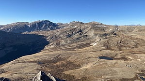
Hike, skirt & scramble to London! by LindaAnn History: London Mountain sits above the North and South London Mines, which tunnels through the mountain to connect. The mountain sits near Mosquito Pass Road, the shortest route between the mining towns of Fairplay and Leadville, CO, and was a toll road in the late 1870s-early 1880s. Numerous mines dot the mountain and surrounding area. Hike: Starting from the junction of CO-12 & FS-856, begin hiking west up CO-12. At this point, the road is high-clearance 4wd and is open for vehicle traffic, so be aware of potential vehicles on the narrow road. The road makes a couple of sharp turns but generally heads south, then west, as it steadily gains elevation. London Mountain is directly south of the road, and the road climbs the north flank of the mountain as it heads west.
From the saddle, turn east and head up the ridge. There is a distinct use-trail to follow, but all you need to do is head up the ridge. You'll soon reach some rock formations "towers" on the ridge. The path does get faint through here, but you can stay on track if you skirt along the rocks' right (south) side. Continue staying on the right side of these rock towers. Near the top of them, you will have to ascend a chute to get above the formations and back on top of the ridge. The footing is steep in places, but you can keep the scramble through the rocks to a Class 2. Look behind you a few times to memorize landmarks, as it will help on the descent. Once above the towers and back on the ridge, the next half mile or so to the summit is relatively easy. Once again, there's a path to follow to the top. At no point on any part of the ridge should you have to travel on the left (north) side of the ridge, all hiking is either on the ridge or just to the right. Once you've soaked in the summit views, retrace your steps back down, carefully through the rock towers. Once back at the saddle, you can head back down the road to your vehicle, or if you are up for a more significant day, continue west up to Kuss Peak to make a loop of Kuss, Mosquito Peak, and Treasurevault Mountain, all of which are 13ers. While this is generally a safe off-trail hike, I would not take kids younger than about 12yrs on this hike unless I was very confident in their abilities due to the steepness around the rock towers. Check out the Official Route and Triplog. Note This is a moderately difficult hike. Leave No Trace and +Add a Triplog after your hike to support this local community. | |||||||||||||||||||||||||||||||||||||||||||||||||||||||||||||||||||||||||||||||||||||||||