Route Editor

| Guide | ♦ | 1 Triplog | 0 Topics |
details | drive | permit | forecast | route |
stats |
photos | triplog | topics | location |
| 0 | 1 | 0 |
History: The area has an extensive mining history, with hundreds of mines dotting the surrounding hillsides. The lower part of the trail passes the profitable North London Mine ruins and follows Mosquito Pass Road, which is the shortest route between the mining towns of Fairplay and Leadville, CO, and was a heavily used toll road in the late 1870s-early 1880s.
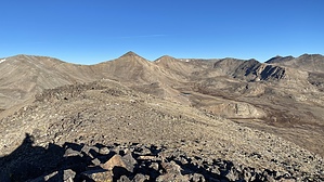
At the saddle, views open up to the north and south, and Mosquito Pass is visible to the southwest. Ambitious hikers can add on a side trip to London Mountain at this point. Otherwise, from the saddle, turn west and head up the ridge towards Kuss Peak, which is easy to identify as it has a couple of towers at the summit. Initially, there is a faint trail and some cairns to follow, but most signs of a path fade away as you head uphill. Carefully climb through the large, blocky talus, checking the rocks for stability as you make your way steeply uphill. Progress is tedious through this section, but ascending is undoubtedly better than it would be to descend these rocks. Once past the worst of the talus, a faint path appears again, and you'll generally stay along the edge of the ridge, making your way to the summit. The top half of Kuss is much easier than the lower half. Once at the summit, head north-northwest across the broad summit towards a large cairn at the summit's northwest end. At the cairn, turn right and descend off the north side of the peak on a faint but discernible trail downhill towards the saddle between Kuss and Mosquito Peak, looming north. Do not take the dirt road. The descent is relatively easy, and you will reach the saddle quickly. At the saddle between Kuss and Mosquito, continue north and up the ridge to Mosquito. Again, do not take the dirt road, which is likely gated anyway. There is a path that is generally easy to follow, but even when it fades at times, your route is obvious. Head north, then northwest up to the summit. At the summit of Mosquito, there is a large cairn. Enjoy the views in all directions from the high point of this loop. Once you're ready to continue, head northwest off the summit, again on a reasonably easy to follow path that heads down towards the next saddle between Mosquito and Treasurevault Mountain. The descent off the north face of Mosquito is very steep. At times, I even scooted down in a few places. There is a path most of the time, but the rocks are loose. Trekking poles are beneficial. Once at the saddle, breathe a sigh of relief, because the rest of this loop is pretty easy. Head directly north towards Treasurevault and back uphill again. The path is obvious the entire way, and the ascent is not as steep as it looks. Again, enjoy the views from the top, then descend the north side of Treasurevault, which is not steep compared to what you've just been through. Coming down, you'll head north as you follow the ridge, then continue to follow the ridge as it curves east. Hiking this ridge is pretty much flat. If you want to cut the loop short, you can head directly east off this ridge down to Cooney Lake below, then follow FS-452 (old mining road) back down to CO-12 and down to your car. However, to make the full loop, stay on the ridge as it heads east until you can see where the ridge turns north again and directly towards Mt Tweto. If you want to add Mt Tweto as a side trip to your loop, follow the ridge directly north then up the mountain. This side trip adds approx 1 mile and 500' to your hike. If you are not hiking Mt Tweto, instead of following the ridge north, turn northeast and head down the slope, continually northeast all the way down the slope to the base of Mt Tweto. There is no trail through here, but it's easy walking. Once you've crossed the slope all the way northeast to the base of Tweto, you should be able to see a faint road directly to your east. Head east on that faint road, or follow the base of the mountain east until you do see the road. The further east you go, the more noticeable the road becomes as it leads to an old mining building and an aerial cable. At this point, the road (FS-856) is very distinct but rocky. Stay on this road as it heads east and south back down to where you parked. Warning: This is a strenuous hike, almost entirely above 12,000'. Start early if there is a risk of thunderstorms. Use caution around the mines, and respect any private property or mining claim notices. Gate Policy: If a gate is closed upon arrival, leave it closed after you go through. If it is open, leave it open. Leaving a closed gate open may put cattle in danger. Closing an open gate may cut them off from water. Please be respectful, leave gates as found. The exception is signage on the gate directing you otherwise. Check out the Official Route and Triplog. Note This is a more difficult hike. It would be unwise to attempt this without prior experience hiking. Leave No Trace and +Add a Triplog after your hike to support this local community. | |||||||||||||||||||||||||||||||||||||||||||||||||||||||||||||||||||||||||||||||||||||||||