username
X
password
register
for free!
help
 
  🔥

East Mountain - Pinal Mountains, AZ

Guide 3 Triplogs  0 Topics
  4 of 5  
Fav
Wish
0
details
drive
no permit
forecast
🔥
route  
stats
photos
triplogs
topics
location
0 3 0
Statistics
tap row or icons for details
Difficulty 3.5 of 5
Route Finding 3 of 5
Distance Round Trip 0.7 miles
Trailhead Elevation 6,552 feet
Elevation Gain 340 feet
Accumulated Gain 349 feet
Avg Time Round Trip 1 hour
Kokopelli Seeds 2.45
 Interest Off-Trail Hiking, Seasonal Creek & Peak
 Backpack Yes
feature photo
Photos Viewed All MineFollowing
18  2020-10-31
Pinal East
DixieFlyer
25  2020-10-22
East Pinal Ladder
DixieFlyer
Author
author avatar Guides 99
Routes 1,484
Photos 16,072
Trips 1,374 map ( 13,602 miles )
Age Male Gender
Location Fountain Hills, AZ
Associated Areas
list map done
Globe Region
Historical Weather
Trailhead Forecast
Radar Map
Expand Map
Preferred Apr, May, Oct, Nov → Early
Seasons   Spring to Autumn
Sun  6:00am - 6:43pm
Official Route
 
3 Alternative
 
Historic Fire Perimetersacres
🔥 PIONEER 200911.4 mi*
🔥 2021 Telegraph Fire266.7 mi**
🔥 2009 Pioneer Fire10.8 mi*
🔥 View (All) - over Official Route 🔥
*perimeter length in miles
**possible voids inflate figure


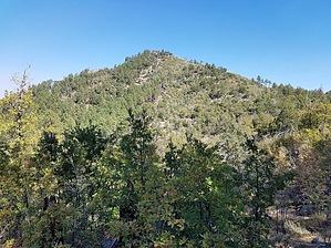
Go East Young Man!
by DixieFlyer

 
Overview
East Mountain (elevation of 6,892' and prominence of 712') is the third highest peak in the Pinal Mountains.


Hike
East Mountain is in the beautiful and rugged Pinal Mountains, in Gila County near the town of Globe.
remove free decal offer
There is no trail going up to the top of East Mountain, but the summit is only a short distance off of East Mountain Trail #214. This trail contours along the forested slopes on the west side of East Mountain.

There are several places that one could leave the East Mountain Trail and hike up to the East Mountain summit. There is no technical climbing involved, although depending on what route you take, the hike up and down could be a bit steep.

The author of this guide went off-trail from East Mountain Trail #214 and ascended East Mountain from the southwest, and descended to the northwest to get back on the trail. This generally followed the route that HAZ user @hikerdw took when going up to East Mountain. This route up was not particularly steep, but there was some manzanita to go through. Thankfully someone had cut a swath through the manzanita, which made going through it relatively painless. The route back down to the East Mountain Trail was steeper, but it was also much shorter. Many hikers would prefer going up and down from the peak to the northwest. It is a good idea to check triplogs and see what route other hikers have taken to reach the summit.

East Peak has a pointed top, so there is not much room to wander around at the summit. The summit has lovely views in all directions, and it is a worthy stop on a clear day.

2020-10-23 DixieFlyer


    Check out the Official Route and Triplogs.
    Leave No Trace and +Add a Triplog after your hike to support this local community.
    WARNING! Hiking and outdoor related sports can be dangerous. Be responsible and prepare for the trip. Study the area you are entering and plan accordingly. Dress for the current and unexpected weather changes. Take plenty of water. Never go alone. Make an itinerary with your plan(s), route(s), destination(s) and expected return time. Give your itinerary to trusted family and/or friends.

     Permit $$
    None


     Directions
    or
     Road
    FR / Dirt Road / Gravel - Car Okay

    To hike
    This is a connector trail, and there is no "trailhead" per se. Instead, the trailhead is whatever point you choose to leave the East Mountain Trail to make an off-trail ascent of East Mountain.
    page created by DixieFlyer on Oct 23 2020 7:26 am
     90+° 8am - 6pm kills
    helpcorrectionissue

    end of page marker