username
X
password
register
for free!
help


Tucker Creek Trail, AR

Guide 2 Triplogs  0 Topics
  1 of 5  
Fav
Wish
0
details
drive
no permit
forecast
route  
stats
photos
triplogs
topics
location
4 2 0
Statistics
tap row or icons for details
Difficulty 1 of 5
Route Finding 1 of 5
Distance Round Trip 6.4 miles
Trailhead Elevation 340 feet
Elevation Gain -50 feet
Accumulated Gain 50 feet
Kokopelli Seeds 6.65
 Interest Perennial Creek
 Backpack No
feature photo
Photos Viewed All MineFollowing
4  2020-11-04 kingsnake
Author
author avatar Guides 116
Routes 337
Photos 11,399
Trips 894 map ( 8,139 miles )
Age 63 Male Gender
Location Sunnyslope, PHX
Associated Areas
list map done
Central Little Rock Region
Historical Weather
Trailhead Forecast
Radar Map
Expand Map
Preferred Apr, Mar, Nov, Oct
Sun  5:44am - 6:33pm
Official Route
 
0 Alternative


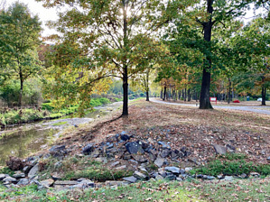
Leg Stretcher While Driving Thru
by kingsnake

 
Tucker Creek Trail (as it is called on the map), or Kinley Trail (as it is called on mileage markers), is a 3.2 mile paved multi-use trail in Conway, AR, just northwest of Little Rock. There is a parallel dirt "mountain bike trail" that is no more challenging than merely riding on the path for some length.


Every .02 to .05 miles, there is a white-on-green mileage marker, usually posted on one of the many trailside light poles.
remove free decal offer
There is no noticeable elevation gain, though the trail does drop slightly as it heads southwest.

Tucker Creek is 10-30 ft. wide, no more than a foot deep at most, and slow-moving. All the Tucker Creek crossings are bridged. Two of the road crossings are tunneled; with one low-traffic exception, the other road crossings are signaled crosswalks.

There is a regular restroom at Gatlin Park and several portapotties along the way.

Also, at various points along the trail are the usual park stuff: doggie doo stations, jungle gyms, picnic tables, rest benches, etc.

Each trailhead, other than at the Walmart, has room for 12-20 cars.

2020-11-07 kingsnake


    Check out the Official Route and Triplogs.
    Leave No Trace and +Add a Triplog after your hike to support this local community.
    WARNING! Hiking and outdoor related sports can be dangerous. Be responsible and prepare for the trip. Study the area you are entering and plan accordingly. Dress for the current and unexpected weather changes. Take plenty of water. Never go alone. Make an itinerary with your plan(s), route(s), destination(s) and expected return time. Give your itinerary to trusted family and/or friends.

     Permit $$
    None


     Directions
    or
     Road
    Paved - Car Okay

    To hike
    From the main Conway hotel cluster at the I-40 / US-65 interchange, head south on Harkrider St. to the Winfield St. traffic circle. (Conway LOVES its traffic circles.) Go right. At the next traffic circle, go "straight" onto Tyler St. In a little over a mile, Gatlin Park will be on your left.
    page created by kingsnake on Nov 07 2020 7:57 am
     90+° 8am - 6pm kills
    helpcorrectionissue

    end of page marker