 Route Editor

| Guide | ♦ | 2 Triplogs | 0 Topics |
details | drive | permit | forecast | map |
stats |
photos | triplogs | topics | location |
| 32 | 2 | 0 |
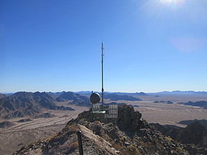
Buck Those More Prominent Summits by Jim  Buck Peak is a rugged hike and scramble in the scenic desert near the Mexican Border. Located in the Cabeza Prieta Mountains' northern section, this peak is visible from a reasonable distance and offers numerous nearby peak views. It does have a small remote radio repeater just off of the true summit. A small peak register placed in 1985 is still present on the summit as of this writing and has an entry every few years. Prior to my entry in December 2020, the last recorded entry was in early 2016. Buck Peak is a rugged hike and scramble in the scenic desert near the Mexican Border. Located in the Cabeza Prieta Mountains' northern section, this peak is visible from a reasonable distance and offers numerous nearby peak views. It does have a small remote radio repeater just off of the true summit. A small peak register placed in 1985 is still present on the summit as of this writing and has an entry every few years. Prior to my entry in December 2020, the last recorded entry was in early 2016.Bring plenty of water, your Barry Goldwater Range Permit, and enjoy. You likely will see no one once hiking. Most of the human tracks I saw were reported to be from Border Patrol.
Take 708 more or less southwest. At the only fork of consequence, the one with the old missile, take a right and continue. The road enters a sandy wash, and you can either subject yourself to this or hike the solid ground to the south, paralleling the wash. This is generally easy cross desert hiking. Because Buck Peak has a tower on it, it is easy to spot from below. Once you can see the saddle at the top of the canyon on the west side of Buck, make for the canyon and enter it, proceeding up to the saddle. There are many Elephant Trees and other pleasant desert vegetation early on, and travel is relatively easy. As you approach the saddle, the boulders become smaller rough rocks, the slope quality decreases, and everyone's favorite plant begins to dominate: jumping cholla. Lots of that here! If you made it to the saddle, the miserable part is done. Proceed up to the summit by a scramble up the class 2 to 3 ridge. The difficulty here is dependent on your taste for the most part. Being hot and sunny, there is more jumping cholla, but it isn't as dense as below. On top, locate the summit register near the benchmark and enjoy the views. A lot of local peaks to pick out! If time allows, there is a wildlife tank to the north you may want to check out and some awe-inspiring granite cliffs higher above it. Several mine shafts are on the way but "closed" per FWS signs. I found the shaft too low to have any desire to enter. BP or other tracks went in a distance, but I don't like hunched over walking. If you skip the mine, tank, and cliffs to the north, returning to your vehicle is easiest the way you came. If you descend the north slope, you must hike around the range. It is possible. Just know there is a lot of loose round rock at times. Alternate access using the road coming in from the north appears to be another viable option. Here you will arrive from the F-10 and F-10C markers on the Barry Goldwater Range. Per HAZ Topo maps, roads on the refuge are listed as restricted once south of the range and closed to the public, most likely at the refuge boundary similar to Rd 708. Because I found descending the north slope to the mine to be in the shade and having fewer cholla than the south slope, this is probably a better option for many. However, the access roads are not tested by me. Check out the Triplogs. Leave No Trace and +Add a Triplog after your hike to support this local community. One-Way Notice This hike is listed as One-Way. When hiking several trails on a single "hike", log it with a generic name that describes the hike. Then link the trails traveled, check out the example. | |||||||||||||||||||||||||||||||||||||||||||||||||||||||||||||||||||||||||||


