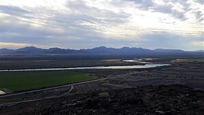
Black Point Hill is the local exercise hike, lightly used by Blythe citizens. Since there are no trails to the tops of mountains around Blythe, locals walk a dirt service road up this hill. There are microwave towers on top of the hill. From the summit, there are great views of the Colorado River, its huge farming valley framed by desert peaks, and the Big Maria Mountains Wilderness, which lies just to the northwest.
On the left, partway up, is the Black Point Intaglio, an ancient geoglyph (or very large petroglyph on the ground), protected by law. You really can't see what it looks like except from an aerial photo. The area is fenced and marked by a sign saying it's an archaeological site. It's okay to walk around in the area as long as you do not damage or remove anything.
The actual summit of the hill is uncluttered and makes a nice rest stop with a view. Return the way you came.
WARNING! Hiking and outdoor related sports can be dangerous. Be responsible and prepare for the trip. Study the area you are entering and plan accordingly. Dress for the current and unexpected weather changes. Take plenty of water. Never go alone. Make an itinerary with your plan(s), route(s), destination(s) and expected return time. Give your itinerary to trusted family and/or friends.
Permit $$
None
Directions
Road
FR / Dirt Road / Gravel - Car Okay
To hike 12.2 miles north of exit 241 off of I-10, Intake Blvd., Blythe, California. Head north on Intake Blvd., which becomes CA 95.
page created by azbackpackr on Nov 12 2020 7:45 am
 Route Editor