username
X
password
register
for free!
help
 

Sedona Caves, AZ

Guide 2 Triplogs  0 Topics
  5 of 5  
Fav
Wish
1
details
drive
no permit
forecast
map
stats
photos
triplogs
topics
location
13 2 0
Statistics
tap row or icons for details
Difficulty 1.5 of 5
Route Finding 1 of 5
Distance Round Trip 0.5 miles
Trailhead Elevation 4,197 feet
Elevation Gain 104 feet
Accumulated Gain 104 feet
Avg Time Round Trip 0.5
Kokopelli Seeds 1.02
 Interest Seasonal Creek & Perennial Creek
unreported if dogs are allowed
editedit > ops > dogs to adjust
feature photo
Photos Viewed All MineFollowing
8  2023-05-07 mikemcg
5  2020-09-17 caragruey
Author
author avatar Guides 4
Routes 52
Photos 1,303
Trips 75 map ( 426 miles )
Age Female Gender
Location Sun City
Associated Areas
list map done
Sedona Region
Historical Weather
Trailhead Forecast
Expand Map
Preferred Mar, Nov, Feb, Apr
Seasons   ALL
Sun  6:03am - 6:48pm
1 Route
 
0 Alternative


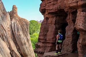
If you have a few minutes to spare
by caragruey

Overview
This is a short and sweet little hike if you have a break in your day, between hikes, or heading out of town. These caves are fun to explore and are located mid-way through this very short 0.5-mile hike.


Hike
You will start straight ahead for the trail, it will start to go downhill on the rocks, and as you come to a sign that says "illegal to deface rocks" (don't miss it) that is where you will make a right turn just past the sign. There are about 4-5 that you can pass through along the side of the mountain. Be careful as they are basically on a cliff. If you are faint at heart or have a heights fear, you may want to stand back and take photos. If not, dive on in, but understand it is a cave. Bats and other critters make them their home.
remove free decal offer
After some cave fun, make your way down to the creek below. Bring your water and snacks, and soak in the views, dip your toes in for a quick cool down. Oak Creek is in critical condition, so make sure to pack out your trash!!!

2020-11-13 caragruey
  • 2021 Verde Valley Trails
    region related
    2021 Verde Valley Trails
  • 2021 Verde Valley Area
    region related
    2021 Verde Valley Area
  • 2021 Sedona Trails Map
    region related
    2021 Sedona Trails Map


Check out the Triplogs.
Leave No Trace and +Add a Triplog after your hike to support this local community.
WARNING! Hiking and outdoor related sports can be dangerous. Be responsible and prepare for the trip. Study the area you are entering and plan accordingly. Dress for the current and unexpected weather changes. Take plenty of water. Never go alone. Make an itinerary with your plan(s), route(s), destination(s) and expected return time. Give your itinerary to trusted family and/or friends.

 Permit $$
None


 Directions
or
 Road
Paved - Car Okay

To hike
I17 N towards Flagstaff, exit 298 for AZ-179N towards Sedona, continue for about 14 miles or at the 7th traffic circle take 4th exit onto AZ-179S, and there is a tiny pull off. Parking can only accommodate 5 cars MAX.
page created by caragruey on Nov 13 2020 4:47 pm
 90+° 8am - 6pm kills
helpcorrectionissue

end of page marker