Route Editor

| Guide | ♦ | 1 Triplog | 0 Topics |
details | drive | no permit | forecast | route |
stats |
photos | triplog | topics | location |
| 2 | 1 | 0 |
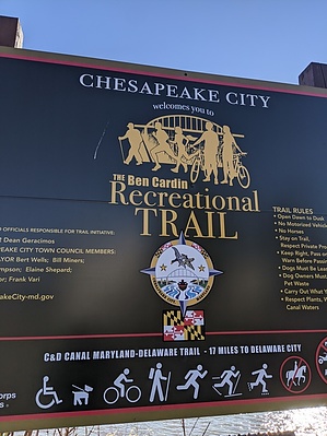
Nice walking trail along the canal by KingLeonidas  The Ben Cardin Trail is the first part of the Chesapeake and Delaware canal trail that runs from Chesapeake City to the Delaware Bay. The trail covers 14.3 miles (one way) all told and is divided into segments named after local people of note. The trail connects to several other trails and features in the following order (from west to east); South Lums Pond entrance, St. Georges Bridge Trailhead, and Biddle Point Trailhead. The Maryland side of the trail is named the Ben Cardin Trail. After crossing into Delaware ~1.8 miles from Chesapeake City, the name changes to Michael Castle Trail. Logistics/Getting there The trailhead is easy to access being in the middle of Chesapeake City right next to Schaefer's Canal House. There is no parking lot at the trailhead, but there is readily available street parking in the area. Many trail users are locals who walk or bike to the trailhead, so there is little demand for public street parking.
The trail is more of a walking path. It is paved and has picnic benches at regular intervals. The first portion of the course passes behind a neighborhood area before going into a wetlands sort of area. The trail is popular with joggers and cyclists getting their daily workout in. There are a few piers at intervals to provide fishing opportunities. General Comments and Musings The trail runs along the canal side, and boats occasionally pass by, providing a change in scenery. This would be an excellent spot to do a long bike ride or possibly a fall leaves-changing-color sort of hike. Check out the Official Route and Triplog. Leave No Trace and +Add a Triplog after your walk/tour to support this local community. | |||||||||||||||||||||||||||||||||||||||||||||||||||||||||||||||||||||||||||||||||||||