username
X
password
register
for free!
help
 

Ridgeline Trail via Overlook Trail - FHP, AZ

Guide 16 Triplogs  0 Topics
  3 of 5  
Fav
Wish
2
details
drive
no permit
forecast
route  
stats
photos
triplogs
topics
location
104 16 0
Statistics
tap row or icons for details
Difficulty 2 of 5
Route Finding 1 of 5
Distance Round Trip 4.18 miles
Trailhead Elevation 2,464 feet
Elevation Gain 870 feet
Accumulated Gain 870 feet
Avg Time Round Trip 2 hours
Kokopelli Seeds 8.53
 Backpack No
feature photo
Photos Viewed All MineFollowing
Will recalculate on button tap!
13  2025-01-09
Adero Meander
FLYING_FLIVER
2  2023-10-04 pseudalpine
12  2023-07-15 DarthStiller
15  2023-01-26
Adero Canyon - Sonoran - Ridgeline
The_Eagle
6  2023-01-26
Adero Canyon - Sonoran - Ridgeline
Tortoise_Hiker
5  2022-03-19 FLYING_FLIVER
22  2021-11-09
Fountain Hills Wander
FLYING_FLIVER
13  2021-01-03 paulhubbard
Page 1,  2
Author
author avatar Guides 47
Routes 96
Photos 850
Trips 385 map ( 2,948 miles )
Age 81 Male Gender
Location Phoenix, AZ
Associated Areas
list map done
Phoenix Region
Historical Weather
Trailhead Forecast
Radar Map
Expand Map
Preferred Feb, Jan, Dec, Nov → 8 AM
Seasons   Late Autumn to Early Spring
Sun  6:03am - 6:49pm
Official Route & 8 Rts
 
4 Alternative


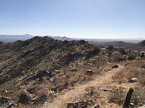
Just One More Hill
by MEWhiteman

Overview
The Ridgeline Trail is relatively new (as of this description in Dec 2020) in the Fountain Hills McDowell Mountain Preserve (FHP), aka Sonoran Preserve of Fountain Hills (SPFH). It is an out and back hike reached by following the Overlook Trail from the Adero Canyon Trailhead. There are 360-degree views from many spots along the hike.


Hike
The Ridgeline Trail is easy to follow and goes along or near a ridge that heads SE from the Adero Canyon Trailhead. As such, it has a sawtooth profile and provides a decent workout over about 4.2 miles round trip and 870 feet aeg. There are numerous switchbacks, so there are no steep sections of trail.
remove free decal offer
From the trailhead, pass through the gate and turn right almost immediately onto the Overlook Trail. At .23 miles (N33.62102° W111.77439°) at the junction with the Easy Access Trail, stay on the Overlook Trail. At 0.48 miles (N33.62019° W111.77262°), turn right onto the Ridgeline Trail. This is where it officially begins. At 1.2 miles (N33.61463° W111.76578°), the trail splits. The trail goes on both sides of the knob giving the hiker different views on the out and back legs. I took the right leg on the way out. At 1.37 miles (N33.61403° W111.76442°), the split rejoins the route. This provides a convenient turnaround for those wishing for a shorter hike.

The main trail continues onward and ends on a hill at 2.09 miles (N33.61016° W111.75992°). Turn around here and retrace your steps back to the trailhead.

Gate Policy: If a gate is closed upon arrival, leave it closed after you go through. If it is open, leave it open. Leaving a closed gate open may put cattle in danger. Closing an open gate may cut them off from water. Please be respectful, leave gates as found. The exception is signage on the gate directing you otherwise.

2020-12-02 MEWhiteman
  • 2025 Map
    area related
    2025 Map


Check out the Official Route and Triplogs.
Leave No Trace and +Add a Triplog after your hike to support this local community.
WARNING! Hiking and outdoor related sports can be dangerous. Be responsible and prepare for the trip. Study the area you are entering and plan accordingly. Dress for the current and unexpected weather changes. Take plenty of water. Never go alone. Make an itinerary with your plan(s), route(s), destination(s) and expected return time. Give your itinerary to trusted family and/or friends.

 Permit $$
None


 Directions
or
 Road
Paved - Car Okay

To Adero Canyon Trailhead
From Loop 101 and Shea Blvd head east on Shea Blvd for 7.8 miles. Then turn left on N Palisades Blvd and continue 1.1 miles. Turn left at the stop sign onto Eagle Ridge Drive and continue 2.4 miles until you reach the Adero Canyon Trailhead. Note that along the way Eagle Ridge Drive first becomes N 143rd Way and then becomes N Eagle Ridge Drive.

• February 2019: There is road construction on Eagle Ridge Dr, and the last mile to the trailhead is on a well-graded, unpaved road. However, that section of the road will ultimately be paved.
• January 2020 FHP writes: Fountain Hills (Parks & Wildlife Dept..480-816-5100): Adero Cyn TH/Parking is presently "only" accessible for parking access at the closed chain link fence ~1 mile "prior-to" TH Parking on N. Eagle Ridge Drive. M-F Trailhead access from ~1 mile up road is only legal from 3pm daily. Sat & Sun TH access from ~1 mile up road is legal from dawn to dusk.
• 2020-02-15 Yoder writes: Road to trailhead parking is closed due to construction. You may want to go to the Sunrise Trailhead parking.
• 2020-11-09 Grasshopper writes: Officially opened, and the road to the Parking / TH is now paved.


From PHX (I-10 & AZ-51) 43 min (32.3 miles)
From TUC (Jct 1-10 & Grant) 2 h 7 min (131 miles)
From FLG (Jct I-17 & I-40) 2 h 28 min (155 miles)
page created by MEWhiteman on Dec 02 2020 5:34 pm
 90+° 8am - 6pm kills
helpcorrectionissue

end of page marker