Overview
One of the multitudes of short trails accessible from the Pima Canyon area of South Mountain. It can be combined with many of the other nearby trails for multiple hike options.
Getting there
This trail bisects the newly named Pima Canyon Loop and can be accessed from many points, including quite easily near the middle of the trail. This guide describes the trail from west to east. From the Pima Canyon trailhead, take the dirt road west to Beverly Canyon, which runs along the power lines. Take Beverly Canyon north to the signed start of the trail.
Hike
Starting from the west end, the trail gradually loses elevation as it generally heads northeast. The footing is good, and the trail is easy to follow. There are signs at all junctions, pointing you in the correct direction.
After about 1/3 mile, there is a large trail leading off to the right. Turning onto that trail takes you directly to the Pima Canyon parking lot. Otherwise, to stay on Beacon Hill, continue straight as you head northeast, now walking along the base of the south side of Santa Cruz Hill. As you pass the hill, the trail gets a little rockier, and you'll hike up the only real elevation gain on this trail--about 50 feet. If you like flat, this trail is for you.
Heading slightly back downhill again, you'll notice some large tailings piles up on your right. The area around the mines is marked as closed, so I didn't venture over there on this trip. Now you are hiking at the base of the north side of Beacon Hill. Unfortunately, this trail does not go to the top of the hill. Instead, ending where it meets the same Pima Canyon Loop trail at the very east end of the park. Taking the loop north eventually brings you to the Beverly Canyon trailhead. Taking the loop south takes you back to the Pima Canyon trailhead, or you can turn around and retrace your steps back west on Beacon Hill, potentially exploring other trails along the way.
When hiking several trails on a single "hike", log it with a generic name that describes the hike. Then link the trails traveled, check out the example.
WARNING! Hiking and outdoor related sports can be dangerous. Be responsible and prepare for the trip. Study the area you are entering and plan accordingly. Dress for the current and unexpected weather changes. Take plenty of water. Never go alone. Make an itinerary with your plan(s), route(s), destination(s) and expected return time. Give your itinerary to trusted family and/or friends.
Permit $$
None
Directions
Road
Paved - Car Okay
To Pima Canyon Trailhead To Pima Canyon Trailhead
This one is a little tough to locate if you're not from the area. It's near Guadalupe Rd. The issue at hand is there are no on-off ramps for Guadalupe Rd. Instead, get off south a mile on Elliot and follow 48th Street north.
Pima Canyon Trailhead is located west off of 48th Street, just south of Guadalupe Road. It's all somewhat confusing. Your first time, go to the intersection of Guadalupe & 48th, then head south. Take the first right and an immediate left into South Mountain/Phx Preserves Park. Follow the access road passing the golf course all the way to the trailhead.
Pima Canyon Trailhead and Marcos de Niza Trailhead are the same now. Long ago, the road continued to Pima Canyon Trailhead.
From PHX (I-10 & AZ-51) 10.9 mi - about 18 mins From TUC (Jct 1-10 & Grant) 101 mi - about 1 hour 32 mins From FLG (Jct I-17 & I-40) 155 mi - about 2 hours 25 mins
 Route Editor

 Overview
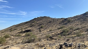


