Route Editor

| Guide | ♦ | 2 Triplogs | 0 Topics |
details | drive | permit | forecast | route |
stats |
photos | triplogs | topics | location |
| 19 | 2 | 0 |
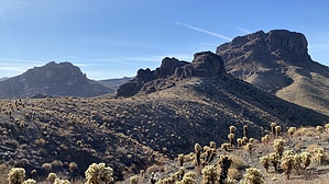
An enjoyable treat by LindaAnn Hike: Starting from the small parking area at the electrical tower, walk back down the road a couple hundred feet to the start of the trail, which is marked by a brown fiberglass trail sign. The trail heads south-southwest up a ridge, steadily gaining elevation. The footing is generally good, but there is some loose rock in places.
While a little dull initially, the geology and terrain steadily get more interesting the further you hike. There are some interesting rock formations, and several arches are visible if you look around. There is plenty of burro and bighorn evidence too. At 2.00 miles, the hike suddenly switches from a relatively easy trail to a steep, easy scramble. You are now ascending the north face of Cupcake Mountain. The trail is still reasonably easy to follow as you head up some chutes. While steep, your hands are mostly only needed for balance, and you don't need to pull yourself up over any rocks. At one point, the chute seems to split, and it seems like there are two options, stay to the left on the more clearly defined, less brushy route, and you'll quickly realize you are still on the correct path. At the top of that chute, you'll reach a small saddle of sorts, then continue to head uphill on the trail. At the base of the summit block, the trail will turn sharply to the right, leading up to the final chute to the summit, which was easily visible from below. As you are traversing up and along the base of the summit block, suddenly the trail will drop about 10', and you have to cross the top of a large crevice/chute. This is probably the most challenging part of the hike since it is steep and the trail is mostly scree right here, plus you are looking down an intimidating drop immediately to your right. Just stay along the wall on your left as you drop the 10' and immediately back up again, again staying against the wall. Once past that, the trail turns left again and heads up the final chute to the summit. There are a few trees in this final chute, but nothing too brushy. Once at the top, head to your left to the highpoint. There are great views in all directions and some places to sit behind a few windbreaks. Heading back down is generally easy since most of the rocks are pretty grippy. While the upper 0.40 miles of this hike is a scramble, there is no exposure of concern. Even crossing the top of the intimidating chute just below the summit is not as bad as it looks. This is a fun short hike, sort of reminiscent of Picacho or Picketpost, but probably slightly easier than those two. I wouldn't attempt this one in the summer. It felt warm on even a cool breezy winter day. Check out the Official Route and Triplogs. Leave No Trace and +Add a Triplog after your hike to support this local community. | |||||||||||||||||||||||||||||||||||||||||||||||||||||||||||||||||||||||||||||||||||||