Route Editor

| Guide | ♦ | 3 Triplogs | 0 Topics |
details | drive | no permit | forecast | route |
stats |
photos | triplogs | topics | location |
| 54 | 3 | 0 |
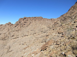
Not the Temple of Doom by DixieFlyer  Overview OverviewKlothos Temple(elevation of 1,666' feet and prominence of 816') is the highpoint of the Muggins Mountain Wilderness and is managed by the Bureau of Land Management(BLM). This wilderness area is about 30 miles east of Yuma, AZ. History Once upon a time, Klothos Temple was known as Coronation Peak.
Travelers across Arizona in the 1850s and later never failed to notice the striking Coronation Peak, so named because the "peaks bear a strong resemblance to those of a mitered crown, and seen in the glow of the setting sun, would readily suggest the idea of that gilded emblem of royalty." The early descriptive name "Coronation Peak" was not destined to endure. The name "Klotho's Temple" was applied by DeLancey Gill, an artist on the Old Yuma Trail exploration party, in November 1900. Klotho is one of the three fates. - Will C. Barnes, Arizona Place Names (Tucson: University of Arizona Press, 1960) Thanks to @chumley for passing this information along. Warning There are no formal trails on this hike, although a few use-trails can be followed. Note that while some of the use trails are nice and easy to follow, they often go to places other than Klothos Temple; thus, be careful if you find yourself following some of these trails. A GPS track will help many hikers, but even with a GPS track, you'll need some good route finding skills for this hike. Hike From the trailhead parking area, begin hiking on the road that you drove in on. This is the start of the Muggins Peak Trail. You'll hike about 300 feet, at which point you will have descended into Muggins Wash. Once in the wash, instead of following the Muggins Peak Trail by taking a right in the wash, look straight ahead or slightly to your left. You will see a wall about 12 feet high that you will need to scale. The wall is at these coordinates: 32.73463,-114.26661 After scaling the wall, you will see a use trail that you will follow for about 1/2 mile until you come to a wash (coordinates 32.74032,-114.26875). Take a right into this wash, and hike through it for 1/2 - 3/4 miles. It is not a strenuous hike as far as washes go, and there is modest elevation gain. After this, you'll find yourself heading uphill through a drainage that is relatively steep with some loose dirt, gravel, and rock. There will be some cairns along the way that will help with route finding. Your target is a ridgeline at the top of the drainage at these coordinates: 32.75193,-114.26578 Once on the ridgeline, you'll want to stop for a short break and enjoy the views. Take a right at the ridgeline, going a bit northeast at first and then mostly north. You'll be traversing along a slope, with some occasional cairns to follow. There is a use trail, but it is not always visible. You'll pass by a couple of false summits, and Klothos Temple won't be visible until you are less than 1/2 mile from it. Klothos Temple is recognizable by its flattish top. As you near Klothos Temple, you'll see a ramp that runs diagonally from the lower right part of the peak to the upper left. Take the ramp up to about 20 feet or so from the summit area. At this point, you should be able to find a class 2 scramble up to the summit. There are some short and seemingly easy class 3 climbs that you can make. However, some of the rock is of questionable quality, so you may wish to be cautious in those areas lest you grab hold of some rotten rock. Once up on the summit, go east for maybe 200 feet to attain the high point. The author of the guide found a summit register and the remnants of a height of light at the summit; however, no surveying markers were located. After enjoying the awesome views at the summit, return the way that you came. Synopsis Even though the elevation on this hike is modest by Arizona standards, it is a fun hike that will challenge most hikers. The area is not all THAT remote, but it is unlikely that you will see other hikers on this one. There is not much vegetation in this desert area, but you will see some fascinating geology and scenic views of this part of Arizona. Check out the Official Route and Triplogs. Note This is a moderately difficult hike. Leave No Trace and +Add a Triplog after your hike to support this local community. | |||||||||||||||||||||||||||||||||||||||||||||||||||||||||||||||||||||||||||||||||||||||||||||||