Route Editor

| Guide | ♦ | 37 Triplogs | 0 Topics |
details | drive | no permit | forecast | 🔥 route |
stats |
photos | triplogs | topics | location |
| 79 | 37 | 0 |
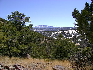
The Alp of Eagar by azbackpackr   Flat Top Mountain dominates the skyline behind the little town of Eagar, Arizona. This is not to say that it is an excellent Alp of a peak, scalable only by experienced mountaineers, using ropes and pitons. No, it's just a flat mesa, rising about 1,000 feet higher than Round Valley, covered with pinon and juniper trees. But it's a favorite of locals for a quick workout with a view. Flat Top Mountain dominates the skyline behind the little town of Eagar, Arizona. This is not to say that it is an excellent Alp of a peak, scalable only by experienced mountaineers, using ropes and pitons. No, it's just a flat mesa, rising about 1,000 feet higher than Round Valley, covered with pinon and juniper trees. But it's a favorite of locals for a quick workout with a view.The Forest Service has designated the old road to the top of Flat Top's rim as a non-motorized trail, suitable for hiking, mountain biking, and horseback riding. There is a locked gate at the trailhead with a large sign on it that says "Road Closed". There is a small parking area here as well, by that gate, and right at the corner of 12th St. and Line St., next to the self-storage units!
While hiking up the Flat Top Trail, you'll notice signs pointing to two side trails. The first one is the aforementioned Robinson Hollow Trail, which begins at the same trailhead. About a mile from the trailhead, the second side trail goes down to Murray Basin and connects with the other end of the Robinson Hollow Trail. You can do a very nice loop hike by taking the Robinson Hollow Trail, at the trailhead and following it around to a T intersection. At this T, turn left and hike up the switchbacks until you get to a second T intersection. Go left again to hike back to the trailhead or go right to get to Flat Top. There are helpful wooden signs at these intersections. The Murray Basin trail system has about fifteen miles of designated non-motorized trails popular with local hikers, horseback riders, and mountain bikers. The Flat Top Trail is a part of this system, which was completed in about 2004. The Forest Service Springerville District office on South Mountain Avenue in Springerville has a free trail guide booklet. It shows the Murray Basin Trail system but does not mention the 12th St. trailhead. Gate Policy: If a gate is closed upon arrival, leave it closed after you go through. If it is open, leave it open. Leaving a closed gate open may put cattle in danger. Closing an open gate may cut them off from water. Please be respectful, leave gates as found. The exception is signage on the gate directing you otherwise. Check out the Official Route and Triplogs. Leave No Trace and +Add a Triplog after your hike to support this local community. | |||||||||||||||||||||||||||||||||||||||||||||||||||||||||||||||||||||||||||||||||||||||||||||||||||||||||||||||||||||||||||||||||||||||||||||||||||||||||||||||||||||||||||||||