 Route Editor

| Guide | ♦ | 5 Triplogs | 0 Topics |
details | drive | no permit | forecast | 🔥 route |
stats |
photos | triplogs | topics | location |
| 0 | 5 | 0 |
Cross at the corners... bring cash! by Daytripper  Brief History Brief HistorySuperior Arizona was previously named Queen then Hastings with a population of 100 in 1880. The Superior townsite itself was laid out in 1902 and named after the Lake Superior and Arizona Copper Company. It supported several mining claims together known as the Silver Queen Mine. By 1910 these were owned by Colonel Boyce Thompson and renamed the Magma Copper Company. Prologue The trailhead is shared with the LOST Canyon Segment. The Legends of Superior Trail acronym LOST now extends from the historic Claypool Tunnel to Picketpost Trailhead and from East to West divided into 5 segments; Canyon Segment, Superior Town Center Segment, Miners and Ranchers Segment, Pinal City Panther Segment, and Arnett Canyon Segment.
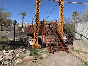
Hike Beginning from the Magma Ave trailhead, the only facility is a picnic table. Proceed right across the sidewalk portion of the concrete bridge over Queen Creek. A short uphill stroll puts you at Main Street across from the Magma Hotel. Don’t bother to cross the street. You will pass by several businesses and eateries, some cash only. Note plaques besides this eclectic collection of buildings indicating prior tenants. After descending about three-quarters of a mile, you will pass by the Main Street entrance for Porters Saloon. Look for concrete steps that descend through the outdoor portion of the saloon. Follow this to the pedestrian bridge crossing back over Queen Creek. Once you descend the steps on the other side, you are at elevation 2740 and have completed this LOST segment.
Check out the Official Route and Triplogs. Leave No Trace and +Add a Triplog after your hike to support this local community. One-Way Notice This hike is listed as One-Way. When hiking several trails on a single "hike", log it with a generic name that describes the hike. Then link the trails traveled, check out the example. | ||||||||||||||||||||||||||||||||||||||||||||||||||||||||||||||||||||||||||||||||||||||||||||||||||||||||||||||||||||||||||||||||||||||||||||||||||||||||


