Route Editor

| Guide | ♦ | 1 Triplog | 0 Topics |
details | drive | no permit | forecast | route |
stats |
photos | triplog | topics | location |
| 41 | 1 | 0 |
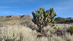
There are no donuts at this Duncan by DixieFlyer   Overview OverviewThe Duncan Benchmark (Elevation of 6,769' and prominence of 2,209') is the highpoint of the Music Mountains and is part of a larger area known as the Grand Wash Cliffs. The Grand Wash Cliffs extend from the Grand Canyon-Parashant National Monument into the Lake Mead Recreation Area, and they cross Grand Canyon, where the Colorado River enters Lake Mead. The Grand Wash Cliffs continue south of the Grand Canyon and east of the Grapevine Mesa Joshua Tree Forest. The Duncan Benchmark is in this southern end of the Grand Wash Cliffs and is about 20 miles from the Grand Canyon Skywalk at Grand Canyon's western end. History The Duncan Benchmark is named for Tap Duncan, who bought a nearby ranch in 1904, naming it the Diamond Bar Ranch. He gradually expanded the ranch, and at one time, he ran 2,000 head of cattle on 1.4 million acres. Today, a portion of the property is known as the Grand Canyon Western Ranch, a working cattle ranch, and a guest resort.
Inquisitive readers of this guide can find more about Tap Duncan via your favorite search engine. Bear in mind that, as with many tales of the old west, it can be hard to separate fact from fiction when reading about Tap Duncan's life. Hike The hike described in this guide ascends to the Duncan Benchmark from a ridge to the southwest of the summit. The hike is totally off-trail. There are no cairns or other markers to guide your way; thus, you'll need some good route finding skills to complete this hike. The terrain is a bit brushy, although the bushwhacking isn't all THAT bad. Most of the brush is about waist-high, and there are a few open areas along with game trails and cattle paths that provide breaks in the brush. From the trailhead, go to the south through a wash for about 3/4 mile. Then, turn to your left and head southeast toward a plateau that is southwest of the Cliffs. As you look up, Grand Wash Cliffs will be on your left, and the plateau will be to the right of the Cliffs. Aim for the right side of the plateau. The climbing steepens as you go up the plateau. Once on the plateau, head eastward toward a ridgeline that will mostly head north to the summit. As you gain elevation, you'll be getting into some pinyon pine and juniper. There will be some steep sections of the climb, so be prepared for that. At the summit, enjoy the excellent views, especially those of the North Rim of the Grand Canyon, off to the NE. Return to the trailhead the same way that you came. This hike is a combination of class 1 and class 2 hiking. The lack of any trail, along with sections of brushy vegetation, makes the hike slower than it otherwise would be. Synopsis If you enjoy solitude on a hike, this one is a good choice, as it is doubtful that you will see another human on the hike. However, with the total lack of a trail and the brushy vegetation, the hike is suitable only for hardy hikers with good route-finding skills. This hike will likely appeal most to peakbaggers, although anyone will enjoy the awesome views at the summit. Check out the Official Route and Triplog. Note This is a moderately difficult hike. Leave No Trace and +Add a Triplog after your hike to support this local community. | ||||||||||||||||||||||||||||||||||||||||||||||||||||||||||||||||||||||||||||||||||||||||