Route Editor

| Guide | ♦ | 1 Triplog | 0 Topics |
details | drive | no permit | forecast | 🔥 route |
stats |
photos | triplog | topics | location |
| 23 | 1 | 0 |
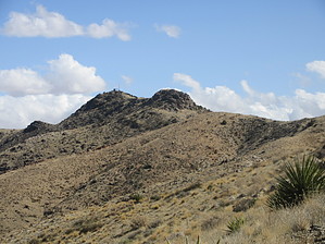
Miles and miles of Arizona by DixieFlyer  Overview OverviewMount Perkins (elevation of 5,459' and prominence of 2,036') is the highpoint of the Black Mountains in northwest Arizona. Mount Perkins is off of Highway 93 between Kingman, AZ and Las Vegas, NV; the turn to the trailhead off of Highway 93 is a bit closer to Kingman than Las Vegas. Hike The parking area is at a saddle that overlooks the Colorado River. You'll see a radio facility a short distance to the west; the Mount Perkins summit is just past some communication towers you will see to the southeast.
There is one rock outcropping that you will have to go around, but it is not a problem. Once you get to the communication towers you have been aiming for; the summit is about 400-500 feet ahead of you. It is easily recognizable by a large summit cairn. At the summit, you will have some nice 360 degree views. Off to the west is the Colorado River; to the north, you can see Lake Mead and Mount Wilson; and you'll see Mount Tipton to the east. After enjoying the nice views, return the way that you came to your vehicle. Synopsis This is a fun and scenic hike, but it is a bit out-of-the-way to get to. For many people, it will be hard to justify the drive for a 2.5-mile hike. In that case, you might want to combine this hike with another hike in the area. Mount Wilson and Mount Tipton are two good choices for the other hike. Check out the Official Route and Triplog. Leave No Trace and +Add a Triplog after your hike to support this local community. | ||||||||||||||||||||||||||||||||||||||||||||||||||||||||||||||||||||||||||||||||||||||||||||||