username
X
password
register
for free!
help


Pima Canyon Loop - South Mountain, AZ

Guide 27 Triplogs  0 Topics
  2.4 of 5  
Fav
Wish
0
details
drive
no permit
forecast
route  
stats
photos
triplogs
topics
location
5 27 0
Statistics
tap row or icons for details
Difficulty 1.5 of 5
Route Finding 2 of 5
Distance Loop 4.42 miles
Trailhead Elevation 1,385 feet
Elevation Gain 174 feet
Accumulated Gain 498 feet
Avg Time Round Trip 2.5 hours
Kokopelli Seeds 6.91
 Backpack No
feature photo
Photos Viewed All MineFollowing
Inaugural Calculation on Button Tap!
8  2024-12-09
Hidden Valley via Guadalupe Ridge
LindaAnn
12  2024-12-09
Hidden Valley via Guadalupe Ridge
The_Eagle
3  2024-04-21
Guadalupe Ridge - AKA Midlife Crisis / Scott
Vashti
6  2024-03-23
Bagel SoMo Mayhem
Nightstalker
5  2023-09-27
San Gabriel Ridge
Tortoise_Hiker
13  2023-09-16
Javelina Canyon Trail
DarthStiller
1  2022-02-22
San Gabriel Ridge
Tortoise_Hiker
8  2021-07-21
Pima Wash Loop from 46th St TH
joebartels
Page 1,  2
Author
author avatar Guides 110
Routes 2,246
Photos 8,982
Trips 2,600 map ( 15,998 miles )
Age 45 Female Gender
Location Ahwatukee, AZ
Associated Areas
list map done
Phoenix Region
Historical Weather
Trailhead Forecast
Radar Map
Expand Map
Preferred Jan, Feb, Nov, Dec → 8 AM
Seasons   ALL
Sun  6:04am - 6:49pm
Official Route & 5 Rts
 
9 Alternative


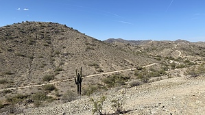
Golf Course Gawking
by LindaAnn

 
Overview: This an easy loop, recently designated as a 'new' trail, utilizing the plethora of existing trails around the Pima Canyon trailhead.


Hike: This loop can be hiked in either direction, although this guide describes it going counter-clockwise ↺. From the Pima Canyon parking lot, the trail starts on the north side of the lot, east of the picnic benches/ramada, and is signed. The trail will immediately drop down into a wash. As soon as you reach the wash bottom, turn right at the trail marker. Surprisingly, this marker is not signed. It's just a brown post, but take the trail that heads east from the post. As you head east, stay on the main trail, and you will see signed trail markers again.
remove free decal offer
The trail is easy, with Beacon Hill on the north side of you and a golf course on your right. Continue heading east, following the signs. This section of the trail has a great variety of Sonoran Desert flora and might be a good choice for tourists wanting to see the local desert plant life without making a big hike. After squeezing around the east end of Beacon Hill, the trail turns north, roughly paralleling the golf course as it makes its way gently uphill.

After passing the signed east end of Santa Cruz Hill, the trail drops back down as it winds its way north and west behind several businesses and an apartment complex. Continuing past the apartments, the trail heads west to meet up with Beverly Canyon trail. Turn left, and take Beverly Canyon south, which will still be signed as Pima Canyon Loop. The trail generally follows the power lines, veering back and forth slightly, as it heads slowly uphill. After passing the turnoff for Ridgeline Trail, the trail will drop down into Pima Wash.

As you climb up out of Pima Wash, the trail reaches the service road, continue south across the road as the trail stays parallel with the power lines. The trail will ascend once more, becoming rocky at times, and at the top of the climb will cross Marcos De Niza Trail. After topping out, the trail will drop again as you descend to the southeast and towards the neighborhood ahead of you. Within a few moments, you will reach the signed junction with Desert Classic Trail. Turn left on Desert Classic/Pima Canyon Loop and head east on a mostly flat trail as the loop brings you back to the main parking lot, completing the hike.

2021-04-01 LindaAnn
  • 2022 South Mountain Park
    area related
    2022 South Mountain Park


Check out the Official Route and Triplogs.
Leave No Trace and +Add a Triplog after your hike to support this local community.
WARNING! Hiking and outdoor related sports can be dangerous. Be responsible and prepare for the trip. Study the area you are entering and plan accordingly. Dress for the current and unexpected weather changes. Take plenty of water. Never go alone. Make an itinerary with your plan(s), route(s), destination(s) and expected return time. Give your itinerary to trusted family and/or friends.

 Permit $$
None


 Directions
or
 Road
Paved - Car Okay

To Pima Canyon Trailhead
This one is a little tough to locate if you're not from the area. It's near Guadalupe Rd. The issue at hand is there are no on-off ramps for Guadalupe Rd. Instead, get off south a mile on Elliot and follow 48th Street north.

Pima Canyon Trailhead is located west off of 48th Street, just south of Guadalupe Road. It's all somewhat confusing. Your first time, go to the intersection of Guadalupe & 48th, then head south. Take the first right and an immediate left into South Mountain/Phx Preserves Park. Follow the access road passing the golf course all the way to the trailhead.

Pima Canyon Trailhead and Marcos de Niza Trailhead are the same now. Long ago, the road continued to Pima Canyon Trailhead.

From PHX (I-10 & AZ-51) 10.9 mi - about 18 mins
From TUC (Jct 1-10 & Grant) 101 mi - about 1 hour 32 mins
From FLG (Jct I-17 & I-40) 155 mi - about 2 hours 25 mins
page created by LindaAnn on Apr 01 2021 12:56 pm
 90+° 8am - 6pm kills
helpcorrectionissue

end of page marker