username
X
password
register
for free!
help
  🔥

Cinch Hook Canyon, AZ

Guide 2 Triplogs  0 Topics
  3 of 5  
Fav
Wish
0
details
drive
no permit
forecast
🔥
route  
stats
photos
triplogs
topics
location
0 2 0
Statistics
tap row or icons for details
Difficulty 3 of 5
Route Finding 3 of 5
Distance One Way 1.55 miles
Trailhead Elevation 6,161 feet
Elevation Gain 989 feet
Accumulated Gain 1,049 feet
Kokopelli Seeds 5.05
 Interest Off-Trail Hiking, Seasonal Waterfall & Seasonal Creek
unreported if dogs are allowed
editedit > ops > dogs to adjust
feature photo
Photos Viewed All MineFollowing
Inaugural Calculation on Button Tap!
20  2025-07-01
FR 607 & 607A (Strawberry North)
CannondaleKid
11  2021-04-10
Pine Creek - Cinch Hook Canyon
The_Eagle
Author
author avatar Guides 41
Routes 1,626
Photos 14,983
Trips 2,760 map ( 18,597 miles )
Age 69 Male Gender
Location Far NE Phoenix, Az
Co-Author
co-author avatarGuides 16,843
Routes 17,472
Photos 24
Trips 1 map (6 Miles)
Age 28 Male Gender
Location HAZ, TrailDEX
Associated Areas
list map done
Payson Region
Historical Weather
Trailhead Forecast
Radar Map
Expand Map
Preferred Apr, Mar, Nov, Oct
Sun  6:01am - 6:48pm
Official Route
 
1 Alternative
 
Historic Fire Perimeteracres
🔥 2011 Sandrock Fire4.6k


tighten up your saddle cowboy
by The_Eagle & HAZ_Hikebot

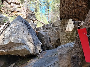
A Boy Scouts route from Pine Canyon to the Rim.

Down below, there is no sign on the Pine Canyon Trail marking the lower beginning of Cinch Hook Canyon. The first 1/2 mile features locust and is slow going. There also are no telltale red metal Boy Scout tags.


The Locust thins out, and the canyon gets more and more interesting. I didn't see my first tag until a half-mile in, and it was a smaller faded tag. There are three falls, slightly difficult areas. With more water flowing, the footing would have been slippery with the moss. The first fall was a ten-footer, followed by a 20' (bypass to the right) and then a 30' that looked daunting at first. I was able to keep my footing by going straight up and to the right.
remove free decal offer
The red markers become more prevalent starting here and appear to have been replaced or added to recently.

After this, the trail levels out and becomes easy. It appears it could be on an old road heading straight for SR87, then turns to the right and heads for another falls area.

The upper TH is not totally evident, but the Official Route marks the Boy Scout Red Tags on SR87.


2020-04-11 The_Eagle & HAZ_Hikebot
  • BSA Routes Map
    area related
    BSA Routes Map


Check out the Official Route and Triplogs.
Leave No Trace and +Add a Triplog after your hike to support this local community.

One-Way Notice
This hike is listed as One-Way.

When hiking several trails on a single "hike", log it with a generic name that describes the hike. Then link the trails traveled, check out the example.
WARNING! Hiking and outdoor related sports can be dangerous. Be responsible and prepare for the trip. Study the area you are entering and plan accordingly. Dress for the current and unexpected weather changes. Take plenty of water. Never go alone. Make an itinerary with your plan(s), route(s), destination(s) and expected return time. Give your itinerary to trusted family and/or friends.

 Permit $$
no fees or permits reported

if incorrect tell us about it


 Directions
or
 Road
Connector trail - Not Applicable

To hike
page created by The_Eagle on Apr 11 2021 10:42 pm
 90+° 8am - 6pm kills
helpcorrectionissue

end of page marker