Route Editor

| Guide | ♦ | 1 Triplog | 0 Topics |
details | drive | no permit | forecast | route |
stats |
photos | triplog | topics | location |
| 20 | 1 | 0 |
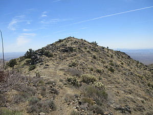
Steep but Sweet by DixieFlyer  Overview OverviewCrossman Peak (elevation of 5,100 feet and prominence of 3,120 feet) is the Mohave Mountain range's highpoint and is located near Lake Havasu City in western Arizona. Even though the summit elevation is modest by Arizona standards, the elevation of nearby Lake Havasu is only 450 feet, so Crossman Peak rises an impressive 4,500 feet from the lake. History The area surrounding Crossman Peak has a robust gold mining history. Along the way to Crossman Peak are several mine adits and shafts. The major mining complex along the trail is the Sunrise Mine, which began operations in 1894 and remained active until the late 1950s.
The majority of this hike is on a service road that leads up to some communication towers. Once at the towers, an easy-to-follow use trail leads to the summit, roughly 1/2 mile from the towers. From the parking area, proceed up the service road for almost 2 miles to the communication towers. After going about 1,000 feet, you'll come to a locked gate that restricts vehicular access. Go past the gate and hike up the steep road, which is Thompson Peak steep in a couple of places. Along the way, you'll pass several abandoned mine shafts and adits -- it is NOT a good idea to enter them. About 1/4 mile below the towers, you'll come to another gate, which was open when this guide's author hiked up to Crossman Peak. There are some signs at the gate warning of radiation danger at the towers and threatening legal action for anyone tampering with the towers. As a result, it is not a good idea to hang around the towers. Instead, walk past the towers and take the use-trail up to the summit. The use-trail follows a ridgeline and has good views down below of Lake Havasu. There are also some Joshua Trees not far below the summit, which are worth checking out along the way. There are some nice 360-degree views at the summit, and it is worth spending some time thereafter the steep climb that you made to get there. Return to the trailhead the same way that you came. On the way down, you'll have nice views of Lake Havasu in front of you the entire way. Synopsis This is a nice hike, especially when considering that most of the hike is on a service road. The climb up is steep through a rather drab desert, but the views at the top make easily justify the effort that it took to get there. Views of Lake Havasu on the descent add icing on the cake! Warning There are 3 things to keep in mind on this hike: 1) There are several abandoned mine shafts and adits along the hike, which could be dangerous to enter. Please resist the urge to enter. 2) It is wise not to spend time at the communication towers that you pass on the way to the summit. 3) Some portions of the service road on the descent are very steep, with some slippery footing on loose dirt. It might be wise to go slowly on these sections to keep from slipping and falling. It is not likely that you would sustain a serious injury, but you could hurt your pride, as this guide's author found out the hard way. Gate Policy: If a gate is closed upon arrival, leave it closed after you go through. If it is open, leave it open. Leaving a closed gate open may put cattle in danger. Closing an open gate may cut them off from water. Please be respectful, leave gates as found. The exception is signage on the gate directing you otherwise. Check out the Official Route and Triplog. Leave No Trace and +Add a Triplog after your hike to support this local community. | ||||||||||||||||||||||||||||||||||||||||||||||||||||||||||||||||||||||||||||||||||||||||