Route Editor

| Guide | ♦ | 1 Triplog | 0 Topics |
details | drive | no permit | forecast | route |
stats |
photos | triplog | topics | location |
| 0 | 1 | 0 |
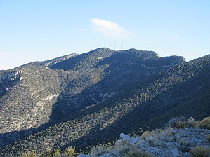
What happens on Potosi stays on Potosi by DixieFlyer Potosi Mountain (elevation of 8,514 feet and prominence of 3,012 feet) is in the southern Spring Mountains, about 30 miles southwest of Las Vegas, NV. Potosi Mountain is surrounded by limestone cliffs on three sides. It is easily recognized from Las Vegas. History The giant cave, Pinnacle Cave, was used for vision quests by the great Chemehuevi shaman of the mid-19th century, O-omposi, for whom the mountain is named. It is a technical cave with a 120-foot vertical entry shaft before going into a series of squeezes. The cave is a frequent site of search and rescue operations.
In 1942 TWA Flight 3 crashed into the side of Potosi Mountain, killing all 22 people aboard. Among the passengers was famous actress Carol Lombard, who was married to Clark Gable. Hike This guide describes the route to the summit on a service road that goes from the south. Another route to the summit that is sometimes used involves an off-trail hike from the west; that route is beyond the scope of this guide. The hike is on a service road used by workers tending to communication towers on the mountain. The average gradient is 12%, and some portions of the road have a 25%-30% grade. You'll gain 1,900 feet of elevation in the first 1.75 miles; fortunately, most of the road is paved on this section, which provides good traction. Thereafter, the grade is much more modest the rest of the way to the summit. You'll be on a ridgeline after these 1.75 miles; at this point, you'll have a good view of the summit and the surrounding area, including Charleston Peak to the north and the Panamint Range to the west. Take the easy-to-follow road all the way to just below the summit block. The final ascent involves a short class 2 scramble alongside some electrical conduit. Be careful to say off the conduit as you go up and down. The summit is a bit of an antennae farm, which isn't aesthetically pleasing. However, the views are great: the Panamint Range to the west; Mount Charleston Peak and Griffith Peak to the north; and the nearby Red Rocks to the east. Return the way that you came. On the way back, many people choose to hike up to Potosi Mountain South. This will add about 300 feet of elevation gain to the hike, but it adds little, if any, distance to the hike. Synopsis This hike has some fantastic views, but some hikers may be less than enthused with the road walk and the communication towers at the summit. In some respects, this hike is similar to hiking up to Thompson Peak in the Phoenix Valley; however, the gradient of the road is not as steep as the steeper sections of Thompson Peak Road, and the views on the hike to Potosi are much, much better than those on a Thompson Peak hike. Sources https://en.wikipedia.org/wiki/Potosi_Mountain_(Nevada) Check out the Official Route and Triplog. Note This is a more difficult hike. It would be unwise to attempt this without prior experience hiking. Leave No Trace and +Add a Triplog after your hike to support this local community. | |||||||||||||||||||||||||||||||||||||||||||||||||||||||||||||||||||||||||||||||||||||||||