 Route Editor

| Guide | ♦ | 2 Triplogs | 0 Topics |
details | drive | permit | forecast | route |
stats |
photos | triplogs | topics | location |
| 0 | 2 | 0 |
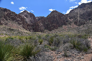
Picturesque Falls by markthurman53 The Rio Grande River comes down out of Colorado, heads south through New Mexico, and passes through El Paso Texas where it now becomes the border between the United States and Mexico. The river flows 1254 miles in a southeast direction toward the Gulf of Mexico, but before getting there, it turns to the North East, creating a momentary bend in the river; this Is Big Bend National Park. The mountains in this park are a continuation of a mountain range in Mexico that will continue into the US through Guadalupe National Park and New Mexico. The highest point in this park is Emory Peak, at 7800 feet. This park is probably one of the remotest parks in the contiguous United States. Despite being in the middle of nowhere, it has a lot to offer in hiking, camping, and general sightseeing. CATTAIL FALLS TRAIL
Cattail Canyon is one canyon to the south of Oak Canyon that Window falls and trail occupy. This canyon has a waterfall not as high as Window falls but still interesting to see. The trail to the falls is near the start of the Oak Spring Trail and doesn’t involve a lot of climbing. This trail is not marked on the park maps to discourage use or at least limit use, but it is a trail with a signed trailhead. The falls are quite picturesque and worth the short hike to them. Below and a bit downstream of the falls is a riparian area with a lot of plant life that you could easily trample. The sign warns to stay on the rocks and don’t wade in the stream. Description From the Ross Maxwell Scenic Road, 3.3 miles from the main park road, there is a dirt road that heads east toward the Chisos Mountains (across from the Nail Ranch Trail). This road used to go all the way to the trailhead of the Oak Spring and Cattail trails. It is now blocked about a quarter-mile in, so the 1.6 miles along this road to the trailhead will have to be walked. The road drops into Oak Creek after 1.6 miles; the Cattail Trail is to the south. The trail starts with a short climb to a ridge that separates Oak Creek from Cattail Creek. Once over that ridge, the trail heads upstream toward the falls. There is a pretty good view overlooking Cattail creek that has cut a pretty good canyon through the alluvium coming off the side of the Chisos Mountains. The trail drops down to the streambed just before the falls, where the vegetation is quite plush. Water was seeping out of the ground all along the trail near the falls. When I was there in April, there was very little water over the falls, and most of the water in the creek was from the springs below the falls. There is quite a bit of poison oak among the vegetation below the falls. Take caution not to trample the vegetation around the bottom of the falls, or this trail may end up being closed off to hikers. This is an enjoyable hike and could easily be done in conjunction with the Oak Spring trail to make an 8 to 9-mile round trip hike. Check out the Official Route and Triplogs. Leave No Trace and +Add a Triplog after your hike to support this local community. One-Way Notice This hike is listed as One-Way. When hiking several trails on a single "hike", log it with a generic name that describes the hike. Then link the trails traveled, check out the example. | ||||||||||||||||||||||||||||||||||||||||||||||||||||||||||||||||||||||||||||||||||||||


