 Route Editor

| Guide | ♦ | 8 Triplogs | 0 Topics |
details | drive | no permit | forecast | 🔥 route |
stats |
photos | triplogs | topics | location |
| 97 | 8 | 0 |
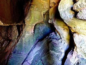
Can a clear creek see forever? by kingsnake   Prologue PrologueIt seems like @The_Eagle does some variation of this hike every year, but there is no guide for it, so here it goes ... Overview East Clear Creek (ECC) starts on the Mogollon Rim, initially draining Lake Draw, Cienega Draw, and Quaking Aspen Canyon. ECC winds ~40 miles northeast, past Miller Canyon and General Springs Canyon; through the C.C. Craigin / Blue Ridge Reservoir; past Barbershop Canyon, Yeager Canyon and the hamlet of Blue Ridge; to Leonard Point, where it joins with Leonard Canyon to form, simply, Clear Creek. In turn, Clear Creek continues north, eventually emptying into the Little Colorado River just east of Winslow.
Starting from Dry Lake, head south on FR 612 for 250 yds to FR 612B. Motorized vehicles are not allowed past the wire-looped gate 250 yds east on FR 612B. A ½ mile into the hike, when FR 612B bends north (left), there is an old fire ring on the right. Turn off the road, heading for the low ground past the fire ring. A ¼ mile past the fire ring, cross FR 612C, on which you will return. After crossing FR 612C, the drainage gets narrower and deeper the next ¾ of a mile to East Clear Creek. The bottom is nearly obstacle-free and often grassy. Travel at the bottom of East Clear Creek is as easy as could be. In many Mogollon Rim canyons, you will find 50 yds of the faint path here or there, but in ECC, there is an obvious path pretty much the whole way to Jones Crossing. The East Clear Creek cave is 3.25 miles into the loop, on the right, on the creek’s shelf. It goes in a fairway. Besides the entrance, there is overhead lighting through a crack. It is much cooler inside. If you wanted to do a shorter day hike from your Dry Lake camp, an out & back to the East Clear Creek cave would be 7.6 miles and 370 ft. AEG. Out & back from Jones Crossing, a trip to the cave is 5.3 miles, 160 AEG. Otherwise, the full loop is 9.7 miles, 560 AEG. From Jones Crossing, take forest roads back to Dry Lake. Several forest roads head south from FR 141 towards Dry Lake, but FR 141 is a "main" dirt road, so the path that uses it least is FR 726D, FR 6437A, and FR 612C. Then off-trail back up to the fire ring on FR 612B and back to the trailhead. Gate Policy: If a gate is closed upon arrival, leave it closed after you go through. If it is open, leave it open. Leaving a closed gate open may put cattle in danger. Closing an open gate may cut them off from water. Please be respectful, leave gates as found. The exception is signage on the gate directing you otherwise. Check out the Official Route and Triplogs. Leave No Trace and +Add a Triplog after your hike to support this local community. One-Way Notice This hike is listed as One-Way. When hiking several trails on a single "hike", log it with a generic name that describes the hike. Then link the trails traveled, check out the example. | ||||||||||||||||||||||||||||||||||||||||||||||||||||||||||||||||||||||||||||||||||||||||||||||||||||||||||||||||||||||||||||||||||||||||||||||||||||||||||||||||||||||||||||||||||||||||||


