username
X
password
register
for free!
help


Rogers Peak - Death Valley NP, CA

Guide 2 Triplogs  0 Topics
  3 of 5  
Fav
Wish
0
details
drive
permit
forecast
route  
stats
photos
triplogs
topics
location
0 2 0
Statistics
tap row or icons for details
Difficulty 3.5 of 5
Distance Round Trip 5 miles
Trailhead Elevation 8,150 feet
Elevation Gain 1,842 feet
Accumulated Gain 1,842 feet
Kokopelli Seeds 14.21
 Interest Off-Trail Hiking, Historic & Peak
unreported if dogs are allowed
editedit > ops > dogs to adjust
feature photo
Photos Viewed All MineFollowing
5  2025-07-09
Telescope Peak Trail
pseudalpine
20  2021-06-14
Telescope Peak Trail
DixieFlyer
Author
author avatar Guides 99
Routes 1,484
Photos 16,072
Trips 1,374 map ( 13,602 miles )
Age Male Gender
Location Fountain Hills, AZ
Associated Areas
list map done
Death Valley Region
Historical Weather
Trailhead Forecast
Radar Map
Expand Map
Preferred Mar, Apr, Oct, Nov
Sun  5:22am - 6:12pm
Official Route
 
1 Alternative


Overview
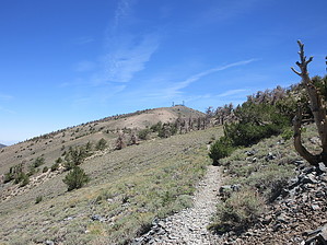
Rogers Peak (elevation of 9,960 feet and prominence of 360 feet) is in the Panamint Mountains and is located in Death Valley National Park.


Hike
From the trailhead, you have two choices to get to the summit of Rogers Peak:
1) Walk up a service road to the summit.
2) Hike about 2.25 miles on the Telescope Peak Trail to a saddle below Rogers Peak, which will be on your right, to the north. Rogers Peak is easily recognizable by the communication towers on top of it. There is a use trail that you can take part of the way up; thereafter, take the path of least resistance to the top. There may be a few cacti and plants in your way, but this is a fairly easy class 1 walk-up.
remove free decal offer
Synopsis
A hike to Rogers Peak is most often done in conjunction with a hike to Telescope Peak. Adding Rogers Peak to the Telescope Peak hike would probably add 1/2 mile and about 300 feet of elevation gain. There would not be much of a reason to go all the way to the trailhead solely to hike Rogers Peak.

2021-06-17 DixieFlyer


    Check out the Official Route and Triplogs.
    Leave No Trace and +Add a Triplog after your hike to support this local community.
    WARNING! Hiking and outdoor related sports can be dangerous. Be responsible and prepare for the trip. Study the area you are entering and plan accordingly. Dress for the current and unexpected weather changes. Take plenty of water. Never go alone. Make an itinerary with your plan(s), route(s), destination(s) and expected return time. Give your itinerary to trusted family and/or friends.

     Permit $$
    NPS


     Directions
    or
     Road
    High Clearance possible when dry

    To hike
    Park at the Mahogany Flat Campground. This is the same trailhead as for the Telescope Peak Trail.

    If you are in a sedan you can fairly easily make it as far as the Charcoal Kilns, a mile or so below Mahogany Flats. Beyond that would be iffy in a sedan, at least in a sedan that you cared much about; but if the road has been recently graded, an SUV will be sufficient to get to the trailhead.
    page created by DixieFlyer on Jun 17 2021 3:55 pm
     90+° 8am - 6pm kills
    helpcorrectionissue

    end of page marker