Route Editor

| Guide | ♦ | 1 Triplog | 0 Topics |
details | drive | permit | forecast | route |
stats |
photos | triplog | topics | location |
| 38 | 1 | 0 |
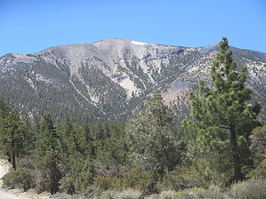
No Pane, No Gain by DixieFlyer Glass Mountain (elevation of 11,160 feet and prominence of 3,180') is in Mono County and the Inyo National Forest. It is located between the Sierras and the White Mountains and has mesmerizing views of both of these ranges. Glass Mountain has a volcanic landscape featuring plentiful deposits of obsidian on its slopes and along the trail to the summit. Obsidian is a volcanic glass, and it gives the mountain its name. History Glass Mountain is the highpoint of the four-mile-long Glass Ridge, which forms the northeastern boundary of what is known as the Long Valley Caldera. During a gigantic volcanic eruption about 760,000 years ago, an area bordered by what is now Mammoth Mountain, Glass Mountain Ridge, and Crowley Lake collapsed to form the Long Valley Caldera, which is approximately 12 miles wide by 18 miles long. The eruption produced the Bishop Tuff, a pinkish-red rock that can be seen along US 395 on the Sherwin Grade. Three hundred and fifty square miles were buried beneath 500 feet of Bishop Tuff. Ash from the eruption has been found as far east as Nebraska. Later, other volcanoes erupted along the rim of this gigantic Caldera, one of which was Mammoth Mountain, which grew on the rim of the Caldera over 50,000 years ago.
Hike The hike is out-and-back on an easy-to-follow use trail. The trail is steep, gaining over 1,900 feet of elevation over the 1.6 miles from the trailhead to the summit. The trail is mostly a mixture of dirt and sand, and you'll pass by abundant fields of obsidian on portions of the trail. The trail travels through pine forests, with the pine species varying along the hike. Jeffrey pine is prevalent near the trailhead, but lodgepole pine begins to dominate as you gain elevation. Nearer the summit, whitebark pine replaces the lodgepole pine, but by the time that you approach the summit the whitebark pines are stunted and are very sparse. While at the summit, you'll want to spend some time taking in the magnificent views. Glass Mountain is sandwiched between the Sierras and the White Mountains, and it has awesome views of both. Long Valley, Crowley Lake, Mono Lake, Montgomery Peak, and Boundary Peak are just some of the landmarks clearly visible from the summit, at least on a clear day. Note that there are two summits on Glass Mountain: the south summit, which the trail leads to, and the north summit, 40 feet lower than the south summit. The route described in this guide goes to the south summit, which is the true highpoint of Glass Mountain. However, the north summit has the survey markers, and most topographic maps mark the north summit, not the higher south summit. On the way back, you may wish to ascend the north summit by descending to the summit plateau and then climbing up to the radio towers on the north summit. The north summit is less than 1/2 mile from the south summit, so ascending it won't add too much additional distance to the hike. Synopsis This is a short, steep, fun hike with great views and some interesting geology and flora. Glass Mountain is in a relatively isolated location, and those looking for some solitude will likely find it on the hike. Peakbaggers may be interested in Glass Mountain: it has over 3,000 feet of prominence and is on the Sierra Club Desert Peaks Section(DPS) peak list. Check out the Official Route and Triplog. Note This is a more difficult hike. It would be unwise to attempt this without prior experience hiking. Leave No Trace and +Add a Triplog after your hike to support this local community. | |||||||||||||||||||||||||||||||||||||||||||||||||||||||||||||||||||||||||||||||||||||||||||||||