Overview: One of two short trails along Red Sleep Mountain Drive (the large loop) in the National Bison Range. These two trail are the only two spots where you are allowed to hike along the loop drive.
Hike: The trail starts on the right (south) side of the road and is well signed. There is room for several vehicles to park along the right side of the road. The trail is wide and in excellent condition as it heads southwest from the road.
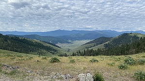
You'll initially walk up a gentle uphill grade before turning left and dropping slightly downhill. Views are excellent as you look across the hills below you and out across the valley. Keep an eye out for wildlife along the edges of the trees, we saw numerous deer in the area, and many visitors have reported grizzlies in the area.
The trail gets a little rocky as you reach the viewpoint at the end of it. Scan the hillsides below you for bison and other wildlife. After enjoying the views, retrace your steps back to the trailhead.
Warning: This is a wildlife refuge; stay alert for animals, and do not approach any along the trail.
WARNING! Hiking and outdoor related sports can be dangerous. Be responsible and prepare for the trip. Study the area you are entering and plan accordingly. Dress for the current and unexpected weather changes. Take plenty of water. Never go alone. Make an itinerary with your plan(s), route(s), destination(s) and expected return time. Give your itinerary to trusted family and/or friends.
Permit $$
As of 2021, the entrance fee is $10 per vehicle.
In late 2020, management of the refuge transitioned from Federal to Tribal responsibility. Follow all Tribal regulations.
Directions
Road
FR / Dirt Road / Gravel - Car Okay
To hike From Missoula: Take I-90 to Exit 96.
Head north on Hwy 92 approx 27 miles to MT-200.
Turn left on MT-200 and take west approx 6 miles to S-212.
Turn right on S-212 and take north 4.70 miles to Bison Range Rd.
Turn right on Bison Range Rd and follow signs to the Visitor Center.
Pay the entrance fee and obtain a park map.
Take Red Sleep Mountain Drive (one-way road) 5-6 miles to the signed trailhead.
 Route Editor