Route Editor

| Guide | ♦ | 1 Triplog | 0 Topics |
details | drive | permit | forecast | route |
stats |
photos | triplog | topics | location |
| 9 | 1 | 0 |
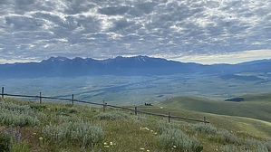
the essence of bison by LindaAnn Hike: From the large parking area, first head to the north end and look at the interpretive signs regarding Glacial Lake Missoula, which has some neat history of the area. After that, head back to the south end of the parking area, where the trail starts on the west side of the restrooms.
When done, retrace your steps back downhill. Warning: This is a wildlife refuge; stay aware of your surroundings. Do not approach wildlife along the trail. Check out the Official Route and Triplog. Leave No Trace and +Add a Triplog after your hike to support this local community. | ||||||||||||||||||||||||||||||||||||||||||||||||||||||||||||||||||||||||||||||||||||||||||