 Route Editor

| Guide | ♦ | 6 Triplogs | 0 Topics |
details | drive | permit | forecast | route |
stats |
photos | triplogs | topics | location |
| 10 | 6 | 0 |
Hike: The trail starts just to the right of the bulletin board and heads north from the Upper Trout Creek Trailhead, starting uphill immediately. The trail quickly turns to the left and heads in a westerly direction, passing a sign listing off the trails in the area.
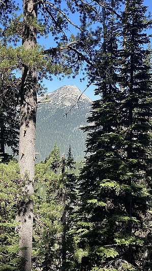
In another three-quarters of a mile, you will reach another signed junction (trails 13 & 41), (Trail# 41 also leads to a nearby lake) and make a sharp left to stay on Trail 13, heading west. Around here, the trees start to thin out, and the views open up. The trail surface also shifts from packed dirt to occasionally walking on granite, and granite boulders litter the hillsides. Pyramid Peak is looming ahead of you and looks like a tempting peak--supposedly, there is a Class 2 route up the south ridge. The trail winds higher and higher as you approach Pyramid Pass. I walked through a small patch of Pink Mountain flowers in this area, which I had never seen before, and their fragrance was amazing. The switchbacks tighten just before you reach the pass, which is shaded but does not have many views. The trail turns to the north at the pass and drops down the other side. As you gradually head downhill over the next half mile, some great views of the Selkirks can be seen through the trees to the west. Even on the last day of June in a dry, warm year, it was obvious that the snow on the north side of the pass had just recently melted. The trail loses about 350' on this side of the pass before ending at the junction with Long Canyon Creek Trail #7, which drops down to the west, and Pacific Northwest National Scenic Trail #221, which continues north towards Long Mountain and beyond. You could probably spend many days exploring this area without getting bored. Long Mountain Lake is also nearby and seems to be a popular backpacking destination. Note: This area has a lot of wildlife, including grizzlies, moose, and wolves; pay attention to your surroundings. Gate Policy: If a gate is closed upon arrival, leave it closed after you go through. If it is open, leave it open. Leaving a closed gate open may put cattle in danger. Closing an open gate may cut them off from water. Please be respectful, leave gates as found. The exception is signage on the gate directing you otherwise. Check out the Official Route and Triplogs. Leave No Trace and +Add a Triplog after your hike to support this local community. One-Way Notice This hike is listed as One-Way. When hiking several trails on a single "hike", log it with a generic name that describes the hike. Then link the trails traveled, check out the example. | ||||||||||||||||||||||||||||||||||||||||||||||||||||||||||||||||||||||||||||||||||||||||||||||||||||||||||||||||||||||||||||||||||||||||||||||||||||||||||||||||||||||||


