username
X
password
register
for free!
help
 This is likely a great time to hike this trail!  Check out "Preferred" months below, keep in mind this is an estimate.
 

Bond Falls, MI

Guide 1 Triplog  0 Topics
  5 of 5  
Fav
Wish
0
details
drive
no permit
forecast
route  
stats
photos
triplog
topics
location
2 1 0
Statistics
tap row or icons for details
Difficulty 0.5 of 5
Route Finding 1 of 5
Distance One Way 0 miles
Trailhead Elevation 1,384 feet
 Interest Perennial Waterfall & Perennial Creek
feature photo
Photos Viewed All MineFollowing
2  2021-06-24 FOTG
Author
author avatar Guides 16,843
Routes 17,472
Photos 24
Trips 1 map ( 6 miles )
Age 28 Male Gender
Location HAZ, TrailDEX
Co-Author
co-author avatarGuides 37
Routes 556
Photos 10,872
Trips 1,052 map (10,600 Miles)
Age 43 Male Gender
Location AZ
Associated Areas
list map done
Northern Region
Historical Weather
Trailhead Forecast
Radar Map
Expand Map
Preferred Jun, Jul, Aug, Sep → 7 AM
Sun  6:20am - 7:30pm
Official Route
 
0 Alternative


nearby historic prize rainbows
by HAZ_Hikebot & FOTG

 Likely In-Season!
Overview
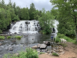
Bond Falls is a natural ~50-foot waterfall located on the Ontonagon River in Michigan's western Upper Peninsula.


Area History
Over six miles downstream, 39-foot Agate Falls cascades over a shelf of erosion-resistant sandstone that halts trout migration. Pools downstream of Agate surrendered prize rainbow trout to ecstatic fly fishers historically but dwindled by the 1960s.
remove free decal offer
Hike
The falls are a popular attraction that can be reached via the developed Bond Falls Scenic Site. A walkway and wooden boardwalk loop around the base of the falls and cross the river above the falls. Bond Falls and the Ontonagon River are stocked with brook trout.


2021-07-19 HAZ_Hikebot & FOTG


    Check out the Official Route and Triplog.
    Leave No Trace and +Add a Triplog after your hike to support this local community.

    One-Way Notice
    This hike is listed as One-Way.

    When hiking several trails on a single "hike", log it with a generic name that describes the hike. Then link the trails traveled, check out the example.
    WARNING! Hiking and outdoor related sports can be dangerous. Be responsible and prepare for the trip. Study the area you are entering and plan accordingly. Dress for the current and unexpected weather changes. Take plenty of water. Never go alone. Make an itinerary with your plan(s), route(s), destination(s) and expected return time. Give your itinerary to trusted family and/or friends.

     Permit $$
    None


     Directions
    or
     Road
    Paved - Car Okay

    To hike
    The Bond Falls Scenic Site is located approximately 3.5 miles outside of the small community of Paulding. Head east on Bond Falls Road and follow the signs.
    page created by FOTG on Jul 19 2021 8:33 am
     90+° 8am - 6pm kills
    helpcorrectionissue

    end of page marker