Route Editor

| Guide | ♦ | 18 Triplogs | 0 Topics |
details | drive | no permit | forecast | map |
stats |
photos | triplogs | topics | location |
| 210 | 18 | 0 |
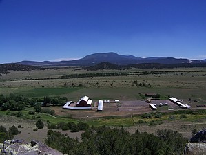
Riparian area with ruins by Crzy4AZ   Sipe White Mountain Wildlife Area is a 1362-acre property managed by the Arizona Game and Fish Department. It offers several short trails, historic and prehistoric cultural sites, and an educational visitors center. The land was purchased in 1993, supports several sensitive species, and provides a winter range for larger animals. There is evidence of human habitation of this area dating from 6000 to 200 BC, which is on display in the visitors center. Sipe White Mountain Wildlife Area is a 1362-acre property managed by the Arizona Game and Fish Department. It offers several short trails, historic and prehistoric cultural sites, and an educational visitors center. The land was purchased in 1993, supports several sensitive species, and provides a winter range for larger animals. There is evidence of human habitation of this area dating from 6000 to 200 BC, which is on display in the visitors center.On one of the trails, you can see the walls of a small village known as Rudd Creek Pueblo, occupied around 1225 AD. The pueblo had about 50 rooms arranged in a single-story rectangular block housing 6 to 8 families with two large kivas. The village was active for 75 years until the inhabitants likely moved north to larger villages along the upper Little Colorado River.
Although the trails are not physically challenging, finding enough time in one day to take in all that Sipe has to offer is your challenge. Watch out for the very popular end of July "High Country Hummers" program at Sipe (850 visitors in 2009), where visitors interact with researchers as four hummingbird species migrate through the area. Trails: Trinity Trail: 350 yards, universally accessible, leads to a wildlife-viewing point adjacent to Trinity Reservoir. High Point Loop Trail: 1 mile, moderate difficulty, viewing points with benches, 20X spotting scope for observing large mammals in the meadows below. Rudd Creek Loop Trail: 3 miles, mostly flat terrain, several wildlife viewing points, and benches. Use this trail (0.5 miles) to see the Rudd Creek Pueblo ruins. Best waterfowl viewing along the McKay reservoir. Homestead Trail: 1.5-mile spur trail (3 total) over flat terrain to the Nelson cabin homestead. More reading: Tiffany C. Clark, Gregson Schachner, Suzanne L. Eckert, Todd L. Howell, and Deborah L. Huntley ?2006 Rudd Creek Pueblo: A Late Tularosa Phase Village in East Central Arizona. Kiva 71:397-428. Check out the Triplogs. Leave No Trace and +Add a Triplog after your hike to support this local community. | |||||||||||||||||||||||||||||||||||||||||||||||||||||||||||||||||||||||||||||||||||