 Route Editor

| Guide | ♦ | 6 Triplogs | 0 Topics |
details | drive | no permit | forecast | 🔥 route |
stats |
photos | triplogs | topics | location |
| 49 | 6 | 0 |
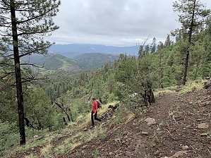
Best Panoramas in the Blue by FOTG  Warning WarningThe Wallow Fire impacted the Horse Ridge Trail in 2011. Hazardous conditions still exist. Trail conditions can change quickly due to winter blowdowns, deadfall, and erosion. Monsoons are capable of producing torrential downpours and high-intensity storms. Plan accordingly and remain vigilant. Overview The Horse Ridge Trail descends 2,000 feet over four miles to its ending at its intersection with the Foote Creek Trail #76. The trail offers some excellent views of the Blue as it descends to Foote Creek, with close-up views of Castle Rock perhaps being the highlight.
A steady ascent through a pleasant forest of ponderosa and various firs marks the beginning of the hike as you leave the trailhead parking lot. A few hundred feet of climbing brings one to the dramatic panorama that marks the beginning of the descent. From there, a trail drops you down steeply along a series of ridgelines on its way to Horse Ridge. After a traverse along the southside of Horse Ridge, the final descent into Foote Creek begins and continues for approximately another mile. At the end of the long ridge, the trail steeply drops into the Foot Creek drainage via several switch backs to its ending point at its intersection with the Foote Creek Trail. Check out the Official Route and Triplogs. Leave No Trace and +Add a Triplog after your hike to support this local community. One-Way Notice This hike is listed as One-Way. When hiking several trails on a single "hike", log it with a generic name that describes the hike. Then link the trails traveled, check out the example. | |||||||||||||||||||||||||||||||||||||||||||||||||||||||||||||||||||||||||||||||||||||||||||||||||||


