Belmont Arch, AZ | HikeArizona
username
X
password
register
for free!
help


Belmont Arch, AZ

Guide 1 Triplog  0 Topics
  0 of 5 
Fav
Wish
1
details
drive
no permit
forecast
map
stats
photos
triplog
topics
location
7 1 0
Statistics
tap icons for details
Difficulty 3 of 5
Route Finding 2 of 5
Distance Round Trip 1.28 miles
Trailhead Elevation 1,594 feet
Elevation Gain 403 feet
Accumulated Gain 403 feet
Avg Time Round Trip 1.5 hours
Kokopelli Seeds 3.3
 Interest Off-Trail Hiking
unreported if dogs are allowed
editedit > ops > dogs to adjust
feature photo
Photos Viewed All MineFollowing
7  2020-12-30 caragruey
Author
author avatar Guides 4
Routes 52
Photos 1,291
Trips 75 map ( 426 miles )
Age Female Gender
Location Sun City
Associated Areas
list map done
Southwest Region
Historical Weather
Trailhead Forecast
Expand Map
Preferred Oct, Nov, Dec, Jan
Seasons   Early Autumn to Early Summer
Sun  6:57am - 6:31pm
Route
 
0 Alternative
 
 Water


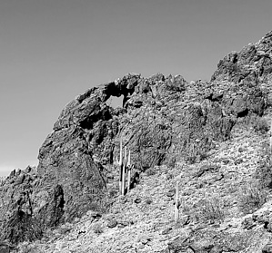
Hot Rock Mountain Gem
by caragruey

 
Overview
A sweet natural arch. The Belmont Mountains is a mountain range in the northern Sonoran Desert about 50 miles west of Phoenix and north of I-10. The dirt roads tend to be a bit confusing, but you can park within a little over 1/2 mile of the arch with a high clearance vehicle. It has a span of 23ft and a height of 20ft.


Hike
Park at N33.61445 W112.93601. Proceed on foot, east into the mighty Sonoran Desert; there is no trail. You will cross a couple of washes with inclines. Once thru those, make your way up the steep and somewhat rocky face keeping the ridgeline to your left. Just under the 1/2 mile mark, give or take, you should then see a family of 5 saguaros tightly clustered. Keep looking up above them as only then the arch reveals itself. From there, it's a rock scramble up to the shelf and into the arch location.

The area is full of loose rock and scree. Be careful as it is a steep climb up. Snakes, scorpions, heat, lack of water, and twisting an ankle are typical dangers. Pitfall Harry rates the adventure as moderate for the prepared. The area is void of quicksand, tarpits, rolling logs, and crocodiles.


Note
You will be parking on the side of the road that is traveled by ATV's etc. Reading the directions might save time and headache vs auto-routing the drive.

Check out the Triplog.

Leave No Trace and +Add a Triplog after your hike to support this local community.

2021-08-13 caragruey
    WARNING! Hiking and outdoor related sports can be dangerous. Be responsible and prepare for the trip. Study the area you are entering and plan accordingly. Dress for the current and unexpected weather changes. Take plenty of water. Never go alone. Make an itinerary with your plan(s), route(s), destination(s) and expected return time. Give your itinerary to trusted family and/or friends.

     Permit $$
    None


     Directions
    or
    or
     Road
    High Clearance possible when dry

    To hike
    I-10 west to exit 98, turn right onto Wintersburg Road stay on Wintersburg rd for about 0.7 miles, then turn left onto W Indian School Rd. after 1-mile turn right onto N 387th Ave, stay on that for about 3.5 miles, turn left onto Orangewood Ave for 1 mile then turn right onto 395th ave for about 0.6 miles then slight left follow for about 4.8 miles Please note the written directions are approximate. I've been in the area several times, and each time google maps have routed me differently. At least twice, it's dead-ended me.
    page created by caragruey on Aug 13 2021 12:46 pm
    helpcorrectionissue

    end of page marker