 Route Editor

| Guide | ♦ | 1 Triplog | 0 Topics |
details | drive | no permit | forecast | 🔥 route |
stats |
photos | triplog | topics | location |
| 18 | 1 | 0 |
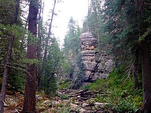
  Slightly congested the first mile. Meadow the next half mile. Congested the next two miles. Easier going the final quarter mile or so to West leonard Canyon. Slightly congested the first mile. Meadow the next half mile. Congested the next two miles. Easier going the final quarter mile or so to West leonard Canyon.Check out the Official Route and Triplog. Leave No Trace and +Add a Triplog after your hike to support this local community. One-Way Notice This hike is listed as One-Way. When hiking several trails on a single "hike", log it with a generic name that describes the hike. Then link the trails traveled, check out the example. | |||||||||||||||||||||||||||||||||||||||||||||||||||||||||||||||||||||||||||||||||||||||||||||


