Route Editor

| Guide | ♦ | 2 Triplogs | 0 Topics |
details | drive | permit | forecast | route |
stats |
photos | triplogs | topics | location |
| 28 | 2 | 0 |
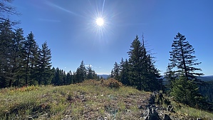
No lambs but maybe a moose by LindaAnn Hike: There is a brown, faded sign for Boundary Peak Trail #325 on the left side of FS-422. The trail initially starts off as a two-track, but after about fifty feet, look to your left for a trail sign nailed to a tree and the trail turning sharply left and uphill. We had to step over some low vegetation from the two-track to the trail. Once on the single track, the uphill starts immediately. There's a switchback at the start, then the trail stays atop the ridge and heads straight uphill. It is steep, but the footing is good. This trail does not seem to get much maintenance, but it is easy to follow. Unfortunately, there is a fair amount of deadfall, but none were difficult to get over or around.
At about two miles, the trail steepens again, then a quarter mile later, turns almost ninety degrees towards the northwest, giving you some glimpses of Lamb Peak directly ahead of you. As you head northwest, you will drop about 200'. Losing that elevation is a bit disheartening since you know you will have to regain it on the hike back out. After the drop, the trail steeply switchbacks up the southeast slope of Lamb Peak, gaining nearly 500' in about a half-mile. The summit of Lamb Peak is mostly devoid of trees, and the highpoint is an obvious cluster of rocks just to the right side of the trail. The rocks are sharp, but we were still able to find a place to sit. While the summit is clear of trees, they still surround you, but there are some good views to the south and west. Lamb Peak sits at roughly the midway point of the Boundary Peak Trail, and those looking for a longer hike can continue on Boundary for another three miles, which includes Boundary Peak itself a mile farther west. But if Lamb Peak was your goal, you will retrace your steps back to the trailhead at this point. The hike back down goes quickly, other than regaining that one hill. The trail surface for the entire hike is good--soil and pine needles, which is easy on the knees. Other than deadfall, the only thing to watch out for is pine branches on the trail that like to roll out from under you. This was a nice hike with almost guaranteed solitude. Drive: The drive out here is almost as nice as the hike. The roads are in great shape and the scenery is beautiful. FS-422 has a few rough spots, but nothing a sedan would have trouble with. Check out the Official Route and Triplogs. Leave No Trace and +Add a Triplog after your hike to support this local community. | |||||||||||||||||||||||||||||||||||||||||||||||||||||||||||||||||||||||||||||||||||||||||