username
X
password
register
for free!
help
 This is likely a great time to hike this trail!  Check out "Preferred" months below, keep in mind this is an estimate.
  

Lake Darling Trail #52 - Cabinet Mtns, ID

Guide 2 Triplogs  0 Topics
  4 of 5  
Fav
Wish
0
details
drive
permit
forecast
route  
stats
photos
triplogs
topics
location
0 2 0
Statistics
tap row or icons for details
Difficulty 2.5 of 5
Route Finding 2 of 5
Distance One Way 4.38 miles
Trailhead Elevation 4,587 feet
Elevation Gain 1,630 feet
Accumulated Gain 1,689 feet
Avg Time One Way 3 hours
Kokopelli Seeds 10.01
 Interest Perennial Creek
 Backpack Yes
feature photo
Photos Viewed All MineFollowing
25  2022-09-14
Lake Darling - Mount Pend Oreille Loop
LindaAnn
21  2021-10-08
Mount Pend Oreille via Lake Darling
LindaAnn
Author
author avatar Guides 110
Routes 2,246
Photos 8,982
Trips 2,600 map ( 15,998 miles )
Age 45 Female Gender
Location Ahwatukee, AZ
Associated Areas
list map done
Northern Region
Historical Weather
Trailhead Forecast
Radar Map
Expand Map
Preferred Jul, Aug, Sep, Oct → 9 AM
Seasons   Summer to Autumn
Sun  6:06am - 7:20pm
Official Route
 
4 Alternative


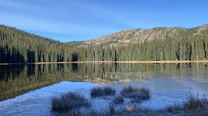
boardwalks cross the boggy areas
by LindaAnn

 Likely In-Season!
Overview: Popular trail along the headwaters of Lightning Creek and Lake Darling. The first half of the trail to Lake Darling is easy, the second half of the trail up to the Pend Oreille Divide Trail is more strenuous.


Hike: The trail starts at the northwest end of the parking area and is well signed. Several signs are there to remind you that this is grizzly country. The trail is in excellent shape as it heads north. You'll quickly cross Gordon Creek, which has a bridge, then will turn northeast, roughly paralleling Lightning Creek below you on your right.
remove free decal offer
The trail heads northeast, then north, gradually gaining elevation, before turning northwest as it approaches Lake Darling after just over two miles of hiking. At the lake, there are a couple of signs directing you north along the eastern edge of the lake, and you'll cross another bridge over Lightning Creek. There are a couple of campsites along the eastern edge of the lake, along with a bear locker and a picnic table and bench. Mount Pend Oreille is clearly visible to the west of the lake.

The trail follows the east side of the lake, then curves around to the north side of the lake. At this point, it is obvious that most of the trail traffic stops at the lake because the trail becomes narrower and less used. Numerous boardwalks cross the boggy areas, helping to keep your feet dry. There are several small creek crossings, but all were easy--might be more difficult in late spring with snowmelt. Vegetation encroaches on the trail for at least the next mile or so as you leave the lake behind and head west more steeply up the side of the ridge. In the autumn, most of the leaves had already fallen off the vegetation, so the trail was mostly clear, but in the summer, you would be pushing through some of these bushes. Pants, not shorts, are suggested because of this mile.

As you climb higher up the ridge, the vegetation clears away from the trail, but the trail becomes rockier and steeper as it approaches its terminus at the Pend Oreille Divide Trail #67. Once you reach the Divide Trail, make sure to step up on the rocks to the west about twenty feet ahead of you for some outstanding views of the Selle Valley and the Selkirk Mountains to the west. The Cabinet Mountains to the east are easily visible too. The hike back down Lake Darling Trail is easy, or you can head north or south on the Divide Trail for additional destinations.


2021-10-08 LindaAnn


    Check out the Official Route and Triplogs.
    Leave No Trace and +Add a Triplog after your hike to support this local community.

    One-Way Notice
    This hike is listed as One-Way.

    When hiking several trails on a single "hike", log it with a generic name that describes the hike. Then link the trails traveled, check out the example.
    WARNING! Hiking and outdoor related sports can be dangerous. Be responsible and prepare for the trip. Study the area you are entering and plan accordingly. Dress for the current and unexpected weather changes. Take plenty of water. Never go alone. Make an itinerary with your plan(s), route(s), destination(s) and expected return time. Give your itinerary to trusted family and/or friends.

     Permit $$
    FS
    Backpacking camping permits: request 2 weeks in advance


     Directions
    or
     Road
    FR / Jeep Road - Car possible when dry

    To hike
    From Coeur d'Alene, take US-95 north to Sandpoint. At Sandpoint, take Hwy 200 East to Trestle Creek Rd. Turn left on Trestle Creek Rd, which turns into FS-275. Take FS-275 up to where it ends at FS-419. Turn left at FS-419 and take it another mile to where the road sign indicates Trail 52 & 161 ahead of you on the left. If you are in a car, park along FS-419 near this sign; if you have medium clearance or better, you can drive the couple hundred feet up to the dirt parking area at the trailhead. There are two or three road signs along the drive, so finding the trailhead is easy.

    FS-275 is car-friendly. FS-419 is rougher, but almost any car could make it if dry. Medium clearance would be better.
    page created by LindaAnn on Oct 08 2021 8:09 pm
     90+° 8am - 6pm kills
    helpcorrectionissue

    end of page marker