 Route Editor

| Guide | 0 Triplogs | 0 Topics |
details | drive | no permit | forecast | route |
stats |
photos | triplogs | topics | location |
| 5 | 0 | 0 |
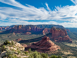
5258 - SW across the Hwy from Bell Rock by roaminghiker   Overview Overview– The Transept to Summit trail offers an invigorating ascent to a lesser-known peak, and its summit features wide views of Sedona red rock formations. The hike starts with a stretch on an official trail, then branches off to a side spur for the climb up to the summit. Hike - Park at the Transept trailhead lot, up Verde Valley School Road, in the Village of Oak Creek, the village itself south of Sedona. As you drive up, the trailhead lot comes up on the left, with an unpaved surface, but no issue for any type of car. The lot has ample space relative to the number who use the trail. I have never seen it full.
At about 0.8 miles Transept rounds a small butte. Nothing unusual, but a tip that the junction to the spur comes soon. Then at 1.2 miles look to the right for the spur. Several spurs branch off Transept, so don’t just take any side trail. When I last took the spur to the summit, a nice cairn sat about 10 feet in on the left-hand side of the spur, a bit hidden, likely to not confuse people on the main trail that the side spur was the main trail. The side spur ascends nicely for the next 0.1 miles, the trail well-defined, traveling up as just a normal trail, a bit rocky, and as could be expected tending towards being overgrown and narrowing. Watch as always for cactus that might be protruding. After this short stretch, the spur enters a fairly steep, boulder-filled shute up. Traversing this section takes some rock scrambling, nothing technical or overly difficult, but some effort and attention are required. I enjoyed it. This stretch runs not too long, about 0.1 miles. Do stay on route, though, as I sensed alternates would likely run into impassible cliffs and bluffs. At the top of the chute, the trail continues up, less steeply, through a wooded section, relatively easy to follow, but again I worked to stay on the GPS track I had. After this, the trail then takes a longer stretch through an open area of low vegetation and crosses over slanted sandstone. Here, I found the trail at points less distinct, more difficult to follow, and occasionally I had to backtrack to stay on course. No scrambling in this section, and at least some parts had reasonable trail definition. Then the trail hits an interesting cliff face (there is a smaller one already, shorter). This second cliff face rises higher maybe 10 feet, but with plenty of offset rock layers providing foot and handholds. No issue to climb, but I did find that a few seconds of planning prevented my starting up a route and getting stuck without a next hand or foothold. After the short cliff face, the trail runs up at a modest grade through the center of a fairly wide ridgeline to the summit. Just make your way through the open vegetation. A large pile of rocks marks the summit. The trail does appear to go beyond, down a ridgeline on the other side. But having made the summit, and with the summit providing excellent vistas in all directions, I didn’t find any reason to proceed on. On the descent down, parts of the trail become even less visible being as visible, as the trail of course now slopes away from one’s line of vision. Now in my exuberance, this led me to veer off at times significantly. So I realized, and just relate here, that the travel down would need to proceed at a deliberate pace, and likely require as much time as the ascent. Overall, two to two and a half hours, but maybe take longer and enjoy the views and hopefully solitude at the top.
Check out the Official Route. Leave No Trace and +Add a Triplog after your hike to support this local community. One-Way Notice This hike is listed as One-Way. When hiking several trails on a single "hike", log it with a generic name that describes the hike. Then link the trails traveled, check out the example. | |||||||||||||||||||||||||||||||||||||||||||||||||||||||||||||||||||||||||||||||||||||||||||||||


