 Route Editor

| Guide | ♦ | 1 Triplog | 0 Topics |
details | drive | permit | forecast | route |
stats |
photos | triplog | topics | location |
| 30 | 1 | 0 |
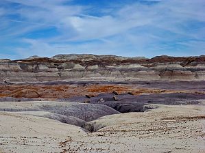
Howd da chowdah? by kingsnake   Petrified Forest National Park has a program it calls “Off the Beaten Path”, which allows visitors to hike off-trail along certain general routes. (It’s okay to wander, but don’t stray too far.) Petrified Forest National Park has a program it calls “Off the Beaten Path”, which allows visitors to hike off-trail along certain general routes. (It’s okay to wander, but don’t stray too far.)This hike has 11 waypoints along its eight-mile length. The trailhead (waypoint 1) is the pullout on the left of Blue Mesa Scenic Rd., at the one-way road split. From there, walk ⅓ mile back down the road to the wooden barriers (waypoint 2) on the other side of the road.
From the Clam Beds, I recommend heading straight towards the other cone (waypoint 5), as the photos don’t always seem to match the route in the Petrified Forest’s 4.3MB brochure. Aim left of the lone juniper (waypoint 6), per the brochure’s photo, even though the map seems to indicate going right, around the low ridge. On the opposite side of the low ridge is a saddle (waypoint 7), this hike's high point. Geographically, anyway. The visual high point, Red Basin, is just ahead. Aim for the old fenceline, then follow it left a few yards to the Sand Castles (waypoint 8) -- which look exactly like some cosmic child played with a 1960s Wham-O sand toy. Rather than try to cross Red Basin’s purple shoal complex (?), it’s easier to follow one of the numerous very twisty washes north from the Sand Castles. Dropping into the nearest wash is maybe 20 ft. After several very tight turns, where the wash begins opening up, look to your right for a butte beautifully layered with red, orange, lavender, purple, white & tan. Waypoint 9 is ⅓ mile north of the Sand Castles. A massive petrified log is 150 yds. past waypoint 9, on the right, at yet another abandoned fenceline. It’s at least 60 ft. long and 5 ft. in diameter. From the massive petrified log, follow the wide wash north-northwest to waypoint 10, which is otherwise unremarkable. Aim for the saddle between the mesa to your left, and the hills to your right. (Actually, ancient sand dunes.) At the top of the saddle, Billings Gap is spread out below. Blue Mesa is on the opposite side of Billings Gap. From the saddle head down across the rosy brown shoal complex, towards the white sandy wash, following it left around another butte to the Billings Gap gate (waypoint 11). If you have had enough for the day, follow the jeep trail 2½ miles back to the wooden barriers at Blue Mesa Scenic Rd. Otherwise, staying on the official route, in ⅓ mile turn off the jeep trail, heading west for Blue Mesa. The Sandstone Congregate Amphitheater is ⅓ mile straight ahead, at the base of Blue Mesa. If you look up, at a fat spire, you may see a petrified log "speared" through it. (Actually, exposed by erosion.) From the natural amphitheater follow washes and/or the edge of Blue Mesa southwest, 1½ miles back to the jeep trail. Take care to avoid the off-limits area, indicated on both the brochure and in this hike's official route. It is ¼ mile on the jeep trail back to the wooden barriers, then ⅓ mile back up the road to the trailhead. Gate Policy: If a gate is closed upon arrival, leave it closed after you go through. If it is open, leave it open. Leaving a closed gate open may put cattle in danger. Closing an open gate may cut them off from water. Please be respectful, leave gates as found. The exception is signage on the gate directing you otherwise.
Check out the Official Route and Triplog. Leave No Trace and +Add a Triplog after your hike to support this local community. One-Way Notice This hike is listed as One-Way. When hiking several trails on a single "hike", log it with a generic name that describes the hike. Then link the trails traveled, check out the example. | ||||||||||||||||||||||||||||||||||||||||||||||||||||||||||||||||||||||||||||||


